
Archives - Page 3
-
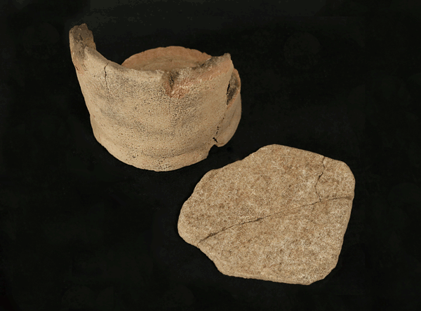
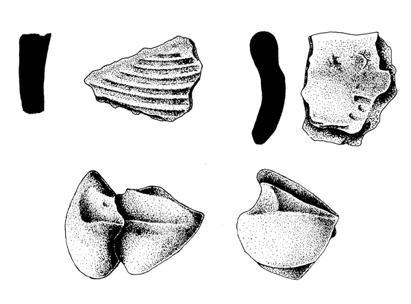
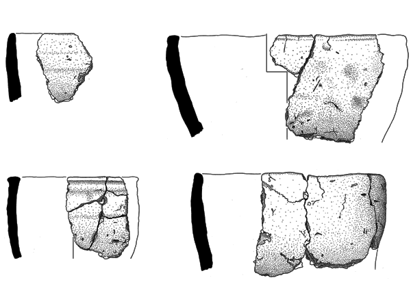
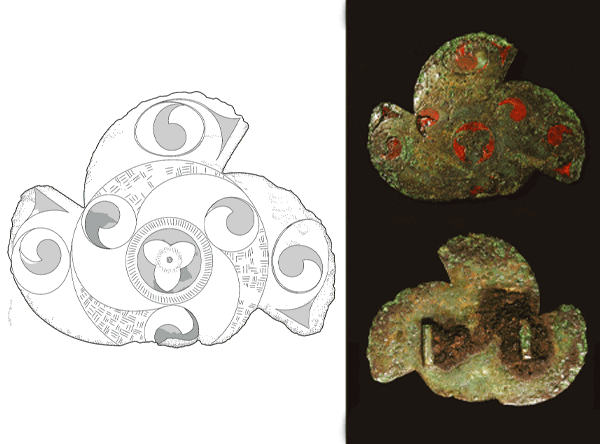
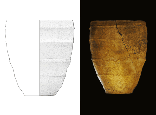
Bronze Age and Iron Age archaeology at Thainstone Business Park, Inverurie, Aberdeenshire: an investigation of structures and funerary practices
Vol. 95 (2021)Bronze Age and Iron Age archaeology at Thainstone Business Park, Inverurie, Aberdeenshire: an investigation of structures and funerary practices
Authors: Sue McGalliard and Donald Wilson
Contributors: Laura Bailey, Hilary E M Cool, Gemma Cruickshanks, Fraser Hunter, Colin Wallace and Michael Wallace
Summary: Headland Archaeology (UK) Ltd was commissioned by Axiom Project Services to undertake an archaeological excavation in advance of a commercial development at Thainstone Business Park, Aberdeenshire (NGR: NJ 7707 1809). Excavation identified the remains of a Middle Bronze Age roundhouse and a contemporary urned cremation cemetery. Evidence of Late Bronze Age cremation practices was also identified. A large roundhouse and souterrain dominated the site in the 1st or 2nd century AD. Material culture associated with the Iron Age structures suggested a degree of status to the occupation there.
Location: Aberdeenshire, Scotland, UK
Periods: Middle Bronze Age, Middle Iron Age
Keywords: souterrain, roundhouse, cremation, urn, prehistoric settlement, prehistoric structure, cemetery

This work is licensed under a Creative Commons Attribution-NonCommercial 4.0 International Licence.
-
The Calanais Fields Project: excavation of a prehistoric sub-peat field system at Calanais, Isle of Lewis, 1999–2000
Vol. 94 (2021)The Calanais Fields Project: excavation of a prehistoric sub-peat field system at Calanais, Isle of Lewis, 1999–2000
Authors: Melanie Johnson, Catherine Flitcroft and Lucy Verrill
Contributors: Mhairi Hastie, Anthony Newton, Adrian Tams and Graeme Warren
Summary: Excavations at Calanais, Isle of Lewis (NGR: NB 2125 3265) in 1999 and 2000, through the University of Edinburgh, revealed fragments of a prehistoric field system buried beneath blanket peat. Stone structures including buildings, walls, clearance cairns and heaps and cobbled surfaces were identified and excavated. Environmental analyses indicate that these features, associated with a buried soil, represent prehistoric farming activity, and radiocarbon determinations indicate that they are likely to be no later than Late Bronze Age or Early Iron Age in origin. This excavation is important as it is one of very few recent prehistoric excavations in the Hebrides on the blacklands instead of machair, in addition to showing evidence for an agricultural landscape in close proximity to a major ritual monument (Calanais Standing Stones).
This paper is dedicated to the memory of Stephen Owen (1979–2017), who brought so much joy to the excavations.
Location: Western Isles, Scotland, UK
Period: Late Bronze Age
Keywords: peat, pollen, palaeosol, phosphate, pumice, prehistoric agriculture
This work is licensed under a Creative Commons Attribution-NonCommercial 4.0 International Licence.
-
Excavations in a prehistoric landscape at Blackford, Perth & Kinross, 2007–8
Vol. 93 (2021)Excavations in a prehistoric landscape at Blackford, Perth & Kinross, 2007–8
Authors: Chris O’Connell and Sue Anderson
Contributors: Ann Clarke, Michael Cressey, Clare Ellis, Mhairi Hastie, Fraser Hunter,
Melanie Johnson and Dawn McLarenSummary: The extensive remains of enclosed and unenclosed prehistoric settlements, including the remains of at least 14 circular structures, were discovered within ten areas of archaeological interest, situated on well-drained knolls in an undulating landscape north of Blackford village. The settlements have been dated principally to the Middle and Late Bronze Age, although continued habitation can be traced through to the Early Iron Age. Most of the structures were probably roundhouses, and were likely to have been the foci of domestic and economic life across generations. The remains ranged from single isolated structures to groups of closely spaced structures. Some were enclosed by palisades, possibly for defence, others were not. Diachronic changes in architecture are readily identifiable. The community made their living from a mixed farming economy, with some craft production also undertaken. Evidence for funerary rites was rare, but what little there was suggests that the dead were cremated and buried in urns.
Location: Perth & Kinross, Scotland, UK
Periods: Middle Bronze Age, Late Bronze Age, Early Iron Age
Keywords: roundhouse, palisade, enclosed settlement, unenclosed settlement

This work is licensed under a Creative Commons Attribution-NonCommercial-NoDerivatives 4.0 International Licence.
-
Doune Roman fort, Stirlingshire: excavations in 1999, 2008 and 2010
Vol. 92 (2020)Doune Roman fort, Stirlingshire: excavations in 1999, 2008 and 2010
Author: Candy Hatherley
Contributors: Jeremy Evans, Martin Goldberg, Kay F Hartley, Mhairi Hastie, Nicholas Holmes, Fraser Hunter, Julie Lochrie, Gwladys Monteil, Effie Photos-Jones, Scott Timpany, David F Williams and Steven H Willis
Summary: Three archaeological excavations were undertaken by Headland Archaeology (UK) Ltd within the grounds of Doune Primary School in Stirlingshire, each located on the site of Doune Roman fort (NGR: NN 7272 0130). These excavations revealed sections through triple-ditched defences, elements of the turf rampart and the perimeter road (via sagularis) on both the west and east sides of the fort. Within the interior of the fort the partial foundations of seven buildings were recovered, including barracks blocks, a corridored building that may represent a workshop (fabrica) and a stable-barracks to accommodate a cavalry squadron (turma). The everyday life of the fort was also revealed, with a series of ovens and an iron-smelting shaft furnace, a first for Roman Scotland. A range of pits were also identified, including some which are likely to be related to the demolition of the fort as it was decommissioned. Artefacts confirm that the fort was built and occupied during the Flavian occupation of Scotland between AD 80 and 86–7.
Location: Stirling, Scotland, UK
Period: Roman, Flavian
Keywords: denarii, barracks, metalwork, furnace, oven, fort
This work is licensed under a Creative Commons Attribution-NonCommercial-NoDerivatives 4.0 International Licence.
-
The excavation of Neolithic pits and a Bronze Age burial site at Ness Gap, Fortrose
Vol. 91 (2020)The excavation of Neolithic pits and a Bronze Age burial site at Ness Gap, Fortrose
Authors: Nuala C Woodley, Julie Lochrie, Alison Sheridan, Trevor Cowie and Claire Christie
Contributors: Julie Franklin, Laura Bailey, Tim Holden, David Henderson and Suzanne McGalliard
Summary: An investigation by Headland Archaeology (UK) Ltd took place in early 2013 in advance of a housing development at Ness Gap, Fortrose, Highland (NGR: NH 73290 56510). The excavation revealed domestic activity dating from the Neolithic to the Early Bronze Age. A cluster of Neolithic pits provided insights into the development of agriculture in the area, with evidence for cereal production and the gathering of wild resources. The use of the site changed in the Bronze Age, with the landscape utilised for funerary practices, which were represented by stone cists and cremation burials, both urned and unurned. Analysis has further informed on the burial practices of the Bronze Age and added to our understanding of a unique peninsular landscape rich in prehistoric activity.
Keywords: burial, cist, cremation, pits, cordoned urn, cinerary urn, faience, metalwork
Location: Highland, Scotland, UK
Periods: Neolithic, Bronze Age

This work is licensed under a Creative Commons Attribution-NonCommercial-NoDerivatives 4.0 International Licence.
-
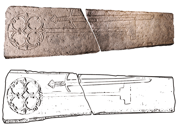
Finding the Blackfriars: excavations at Old High School, Infirmary Street, Edinburgh
Vol. 90 (2020)Finding the Blackfriars: excavations at Old High School, Infirmary Street, Edinburgh
Authors: Donald Wilson, Julie Franklin, David Henderson, Peter Ryder and Richard Fawcett
Summary: Redevelopment of the Old High School, Edinburgh (NGR: NT 2615 7347), provided an opportunity to investigate the speculated location of a Dominican friary, known to have been founded in the early 13th century. The site was also the known location of the 16th-century Royal High School, a predecessor of the present Old High School building constructed in 1777. The scope of the archaeological work included the excavation of a relatively small area to the front of the Old High School building. This area contained some of the most significant archaeological remains recently found in Edinburgh’s Old Town. These included an early medieval boundary ditch; the surviving remains of two walls, interpreted as being associated with the medieval Dominican friary church and 88 accompanying burials spread across three distinct areas. Six of these burials were radiocarbon dated, returning a range of dates between the 13th and 17th centuries, providing the first clear evidence of the existence of the friary in this location. The most significant of the burials was associated with a cross slab grave cover and located in an area interpreted as the claustral area of the friary. Both the cross slab and the associated burial were dated to the late 13th century. Further stone wall foundations relating to the 16th-century Royal High School building were also identified within the excavation area. Several further features ranging from medieval stone-lined drains to 19th-century walls and culverts were recorded during further groundworks across the remainder of the site.
Keywords: friary, boundary ditch, cross slab, grave slab, burial, window glass
Location: Edinburgh, Scotland, UK
Periods: medieval, Early Modern

This work is licensed under a Creative Commons Attribution-NonCommercial-NoDerivatives 4.0 International Licence.
-
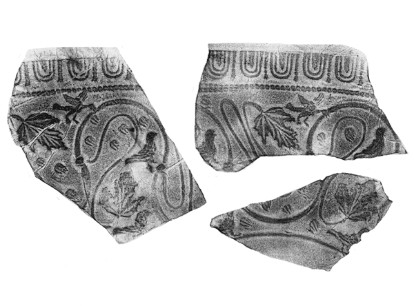
Excavations at Musselburgh Primary Health Care Centre: Iron Age and Roman discoveries to the north of Inveresk Roman Fort, East Lothian
Vol. 89 (2020)Excavations at Musselburgh Primary Health Care Centre: Iron Age and Roman discoveries to the north of Inveresk Roman Fort, East Lothian
Author: Magnus Kirby
Contributors: Sue Anderson, Paul Bidwell, Ann Clarke, Hilary E M Cool, Mike Cressey, Alex Croom, Gemma Cruickshanks, Clare Ellis, Jane Evans, Darren R Gröcke, Kay Hartley, Eniko Hudak, Fraser Hunter, Melanie Johnson, Dawn McLaren, Janet Montgomery, Joanna Moore, Geoff Nowell, Vanessa Pashley, Alice Rose, Jennifer Thoms, Roger Tomlin and Felicity C Wild
Summary: An excavation was undertaken by CFA Archaeology Ltd (CFA) between August and November 2010 on the site of the new Musselburgh Primary Health Care Centre. The site, which lies to the south of Inveresk Road, is centred on NGR: NT 3428 7224. Until its demolition, the area had been occupied by Brunton Wireworks. The Scheduled Monument of Inveresk Roman Fort lies at the top of the steep slope c 50m to the south of the excavation site. The excavation identified six phases of activity on the site, the earliest being a Mesolithic flint scatter. The area was used as a burial ground in the Iron Age and a ring ditch may also be of prehistoric date. Later, six Roman inhumation burials (four of which had been decapitated) and a horse burial were interred, and a possible Roman fortlet was constructed. Across the site, a network of interconnected ditches formed part of a Roman-period field system, which cut through the rampart of the possible fortlet, and through a number of the graves. Along the southern boundary of the site a large accumulation of Roman midden deposits overlay features associated with the field system, although it may have started to build up while the latter was still in use. A post-built structure was also found, one post of which cut a ditch of the field system. The midden deposits extended along the full length of the southern boundary of the site, measuring 110m long by up to 20m wide. Numerous artefacts were recovered, representing the rubbish and discarded personal belongings of the fort occupants. The pottery included samian bowls with personal names scratched on the bases. Evidence from these, together with isotopic analysis of the human skeletons, shows that the ethnic origin of those living in the fort was diverse, as would be expected for the Roman army.
Keywords: field system, burial pits, pottery, iron, bones, midden deposits, rampart base, horse burial
Location: East Lothian, Scotland, UK
Periods: Iron Age, Roman

This work is licensed under a Creative Commons Attribution-NonCommercial-NoDerivatives 4.0 International Licence.
-
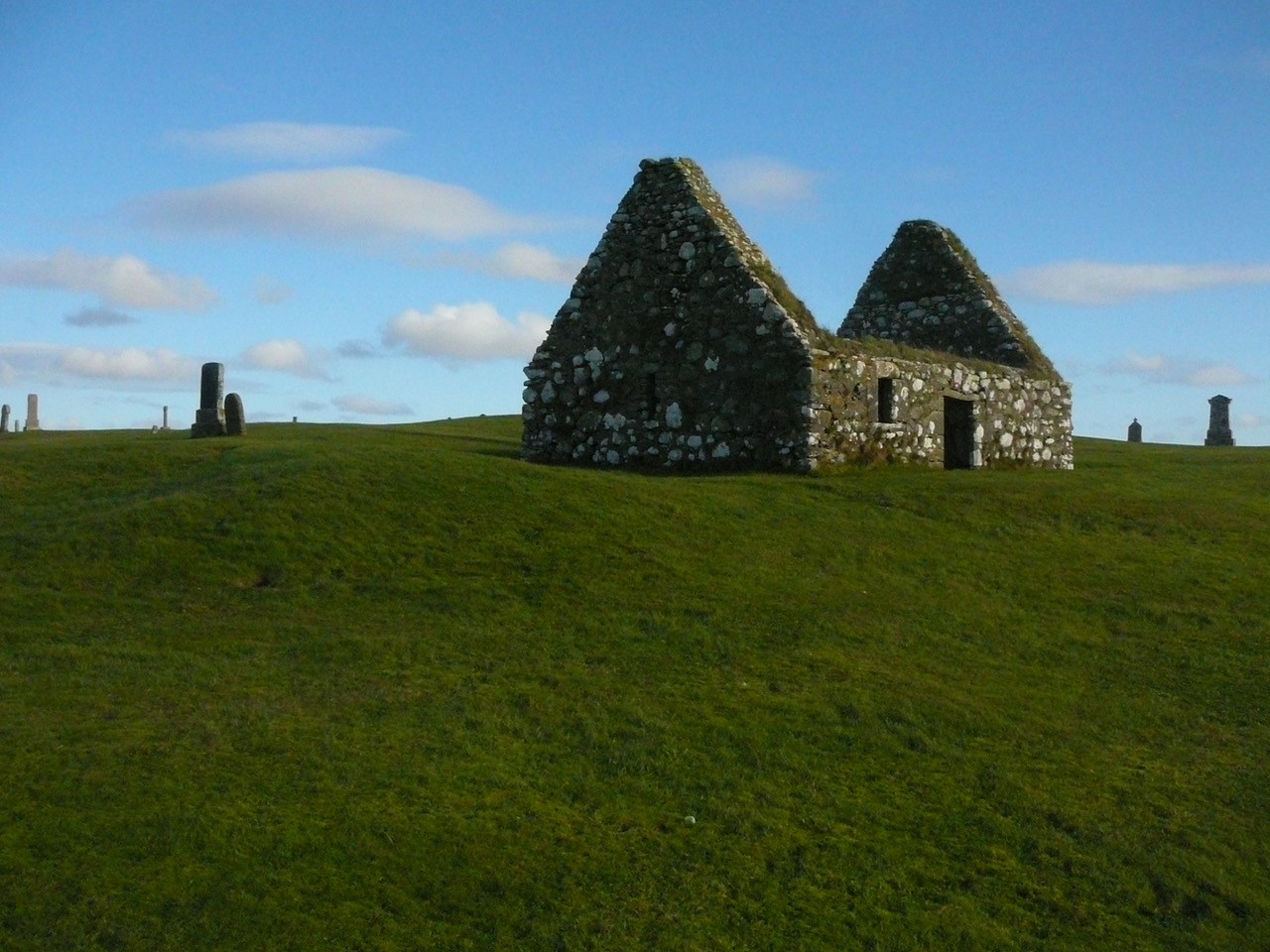
Chapel-sites on the Isle of Lewis: results of the Lewis Coastal Chapel-sites Survey
Vol. 88 (2020)Chapel-sites on the Isle of Lewis: results of the Lewis Coastal Chapel-sites Survey
Author: Rachel C Barrowman
Contributors: Charlotte Francoz, Janet Hooper, Christine Rennie and Gary Tompsett
Summary: The Lewis Coastal Chapel-sites Survey undertook research and fieldwork, the latter between 2004 and 2008, to explore and record the known chapel-sites on the Isle of Lewis in the Western Isles of Scotland. There is a scarcity of surviving contemporary historical documentation relating to Lewis in the medieval period, but archaeology has great potential to further investigate these fascinating and diverse sites. Research linked together previous antiquarian and local historical research, with walkover survey and description of each site on the ground. This was followed by targeted topographic and geophysical surveys of particular sites. At the end of the project it was possible to assess the cultural and research potential of this remarkable group of sites, and to identify gaps where further work was needed. More than 40 sites were identified and the remains recorded at each site were varied, some associated with old settlements, or traditionally linked with other chapel-sites nearby, others alone and isolated. The chapels themselves ranged from upstanding buildings still used for worship, to low grassy banks only just discernible beneath the turf or unlocated and kept alive only in oral tradition. This publication reports on the results of the survey work with a brief conclusion of the main findings.
Keywords: Isle of Lewis, chapel, church, early Christian, medieval, survey, Hebrides, Western Isles, Na h-Eileanan Siar
Location: Western Isles, Scotland, UK
Periods: early medieval, medieval, post-medieval

This work is licensed under a Creative Commons Attribution-NonCommercial-NoDerivatives 4.0 International Licence.
-
A matter of life and death – trade and burial around St Giles’ Cathedral: archaeological investigations at Parliament House, Edinburgh
Vol. 87 (2019)A matter of life and death – trade and burial around St Giles’ Cathedral: archaeological investigations at Parliament House, Edinburgh
Author: Mike Roy
Contributors: Ruby Cerrón-Carrasco, Antonia Craster, Morag Cross, Naomi Crowley, Jane Evans, Julie Franklin, Allan Hall, Derek Hall, Nicholas Holmes, Robin Inglis, Harry Kenward, Melissa Melikian, Catherine Smith, Clare Thomas, Jennifer Thoms, Lindsey Thomson, Scott Timpany, Ronan Toolis and Penelope Walton Rogers
Summary: Archaeological evaluation of the Southern Courtyard of the Parliament House complex (NGR: NT 2577 7350), to the south of St Giles’ Cathedral in Edinburgh’s Old Town, has provided a valuable insight into the lives, health and mortality of the inhabitants of the late medieval city. The evaluation revealed a backland area in the centre of medieval Edinburgh, with deposits rich in artefactual and ecofactual material derived from the everyday lives of the populace, underlying early burghal surfaces. The presence of artefacts including a small leather assemblage and a seal matrix may indicate production and trading activities between the High Street and the Cowgate in the late medieval period. Above these surfaces, and underlying fragmentary evidence of the post-medieval Meal Market, numerous late medieval inhumations were recorded; these belonged to the southward expansion of St Giles’ graveyard. This report details the analysis of the skeletal remains, illuminating the health and demography of the population of the city from around the mid-15th to the early-to-mid-16th century.
Keywords: burial ground, cathedral, seal matrix, Parliament House
Location: Edinburgh, Scotland, UK
Periods: medieval, post-medieval, 16th century

This work is licensed under a Creative Commons Attribution-NonCommercial-NoDerivatives 4.0 International Licence.
-
‘Great fears of the sickness here in the City … God preserve us all …’ A plague burial ground in Leith, 1645: an archaeological excavation at St Mary’s (Leith) RC Primary School, Leith Links, Edinburgh
Vol. 86 (2019)‘Great fears of the sickness here in the City … God preserve us all …’ A plague burial ground in Leith, 1645: an archaeological excavation at St Mary’s (Leith) RC Primary School, Leith Links, Edinburgh
Author: Megan Stoakley
Contributors: Richard Newman, Anne Crone, Lynne F Gardiner, Adrian Bailey, George Haggarty, Janet Montgomery, Mandy Jay, Geoff Nowell and Jo Peterkin
Summary: In 2016, Wardell Armstrong undertook an archaeological excavation at St Mary’s (Leith) RC Primary School, Edinburgh (NGR: NT 27750 75980). The archaeological excavation revealed four phases of activity; Phases 1 and 2 comprised coffined and uncoffined human burials. The lack of infectious pathognomic skeletal lesions, the dating of the finds, the dendrochronological analysis of the coffin wood and technological data, along with the known historic land-use of the area, all indicate that the burial ground relates to the 1645 outbreak of plague in Leith. Dendrochronological analysis revealed a terminus post quem felling date of c 1640 for the coffin wood, while analysis of the coffins’ manufacture revealed hasty construction methods. Phase 3 comprised a series of waste disposal pits of 19th-century date. Phase 4 comprised levelling deposits, which were likely associated with the construction of the school and the demolition of the 19th-century smallpox hospital located to the north of the site. A total of 81 individuals were interred at the site. Adults represent 68.3% while non‐adults represent 31.7%. All age groups were present except neonates. Artefacts including keys, coins, sewing kits and combs were recovered. That the bodies were interred seemingly fully clothed and the corpses not rifled prior to burial strongly indicates a fear of the diseased corpse. The presence of everyday items on the bodies may also indicate a more sudden death outside the sick bed, possibly indicating the occurrence of septicaemic plague. Frequent occupation and attrition-related skeletal and dental pathologies indicate lives characterised by poverty and toil. Strontium analysis revealed that almost all individuals were local to Leith; several individuals had rosary or paternoster beads, indicating a likely Catholic affiliation, which would have been risky given that the pro-Presbyterian Covenant was signed in Leith in 1638. In contrast to older children, the younger children were interred in coffins, indicating differing views on the treatment of the body.
Keywords: bubonic plague, 1645, Leith Links, catastrophic cemetery population, Covenant, beads
Location: Edinburgh, Scotland, UK
Period: 17th century

This work is licensed under a Creative Commons Attribution-NonCommercial-NoDerivatives 4.0 International Licence.

