
Archives - Page 2
-
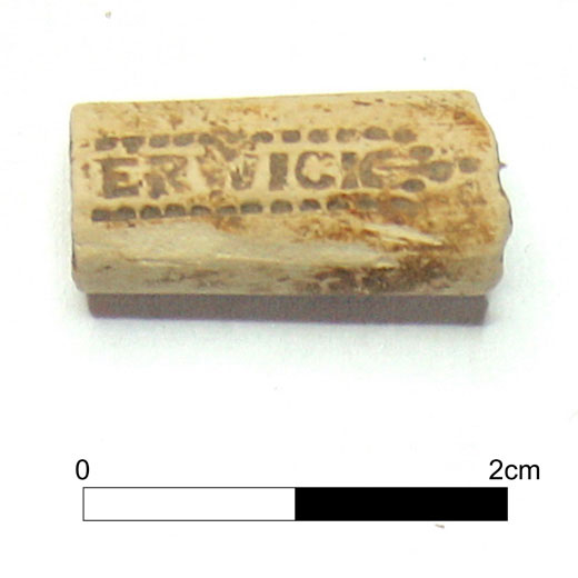
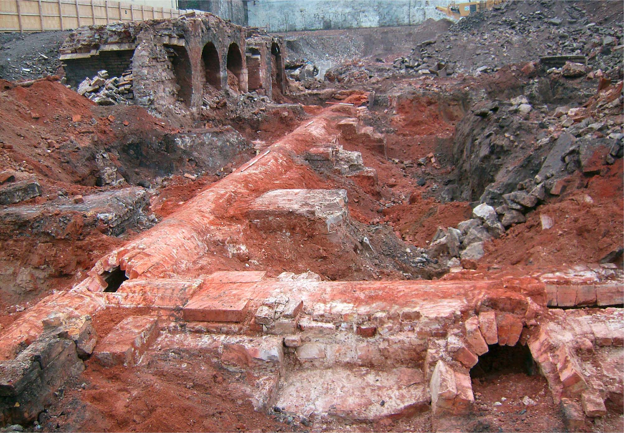
Hume Village and Castle: the setting of a late medieval stronghold and post medieval folly in the Scottish Borders
Vol. 105 (2023)Hume Village and Castle: the setting of a late medieval stronghold and post medieval folly in the Scottish Borders
Authors: Ian Hill and Michelle Gamble
Contributors: Derek Hall, George Haggarty, K Robin Murdoch, Fraser Hunter, Calum Robertson, Carl E Savage, Jennifer Thoms, Iain Pringle and Leilani Lucas
Summary: A three-year community archaeology project was completed on behalf of the Hume Castle Preservation Trust at the village of Hume in the Scottish Borders. The project engaged with over 300 members of the public, providing training and volunteering opportunities in a suite of archaeological skills. The project work focused on Hume Village and its surrounding landscape; in particular Hume Castle and the remains of the former medieval village immediately surrounding it, and the associated kirkyard which housed the former Hume Parish Church. Extensive survey work was completed in the kirkyard and adjacent Glebe, in the grounds of Hume Castle, and at the castle itself. Excavations were completed in the castle grounds, the Glebe, and in the garden of West End Cottage in Hume Village. The results of the survey and excavation works portray the changing settlement pattern and use of land in the village area, particularly highlighting occupation and use of the former buildings surrounding the castle up to 200 years after its destruction. A similar pattern was found in the kirkyard, with continual use of the cemetery over 300 years after the abandonment, and probable destruction, of the former kirk. The results indicate that despite the destruction of its castle and kirk, the village of Hume has persevered, maintaining an important sense of place and memory in the landscape.
Keywords: Late medieval, post medieval, community archaeology, folly, settlement patterns, Scottish Borders
Location: Hume, Scottish Borders, Scotland, UK
Periods: Late Medieval, Post Medieval, Early Modern
Canmore ID: 58561, 58559, 58550, 367583

This work is licensed under a Creative Commons Attribution-NonCommercial 4.0 International Licence.
-
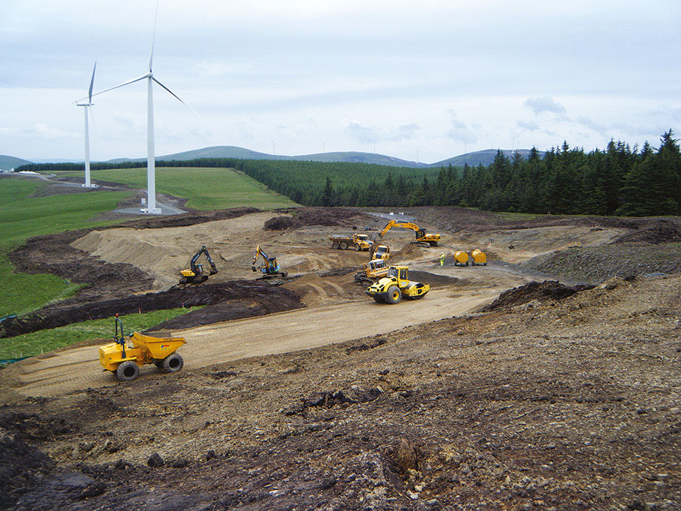
‘Sae lofty and wide’: the archaeology of the Clyde Wind Farm
Vol. 104 (2023)‘Sae lofty and wide’: the archaeology of the Clyde Wind Farm
Authors: Stephen Cox and Nuala Marshall
Contributors: Laura Bailey, Julie Franklin, Fraser Hunter and Angela Walker
Summary: Archaeological investigations undertaken by Headland Archaeology (UK) Ltd as part of the Clyde Wind Farm and Clyde Wind Farm Extension construction project produced a body of evidence that tells the story of human occupation and settlement in the Upper Clyde Valley. The investigations conducted between 2007 and 2015 included evaluations, site excavations, and the monitoring of groundworks across four distinct landscapes: Clyde Valley North (Woodend), Camps Valley, Midlock Valley, and Clyde Valley South (Newton Plantation). The results of this work, together with those from specialist studies and scientific analyses, have allowed for a range of key research questions to be addressed. These include an exploration of prehistoric upland activities, the role of pits and special places, and the development of settlement patterns and structures. Evidence for mobile Mesolithic and Neolithic communities was identified across the landscape with indications of the repeated visitation of specific locations. The role of pits in the creation of special places was particularly evident across Camps and Midlock Valleys. In the 2nd millennium bc, the hillsides were transformed by the creation of platform settlements. Enclosed settlements and hillforts appeared along the banks of the Clyde Valley in the 1st millennium bc marking a distinct shift in the role of landscape in expressing status and identity. In addition to prehistoric remains, limited evidence of early historic metalworking and medieval rural settlement was uncovered. Across all landscapes and periods, the themes of transition and transformation came to the fore, painting an increasingly dynamic picture of life in the Upper Clyde Valley. The scale and complexity of the archaeological works also allowed for a review of current methodologies, including the role of an Archaeological Clerk of Works, with implications for future strategies.
Keywords: landscape, uplands, settlement, pits, platform, settlement, enclosure, hillforts, routeways
Location: Upper Clyde Valley, South Lanarkshire and the Scottish Borders, Scotland, UK
Periods: Mesolithic, Neolithic, Bronze Age, Roman & Iron Age, early Historic, Medieval
This work is licensed under a Creative Commons Attribution-NonCommercial 4.0 International Licence.
-
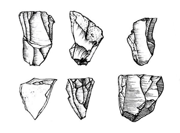
A time of change: Mesolithic occupation at Cramond, Edinburgh during the 9th millennium BC
Vol. 103 (2023)A time of change: Mesolithic occupation at Cramond, Edinburgh during the 9th millennium BC
Authors: John A Lawson, Alan Saville and Rob Engl
Contributors: Andrew Bicket, Rosie Bishop, Valerie Dean and Mhairi Hastie
Summary: In 1995 small-scale excavations undertaken at Cramond, Edinburgh revealed a number of pit and post hole features related to temporary or intermittent Mesolithic occupation. These features and associated deposits produced sizeable assemblages of charred plant remains and lithic material.
Cramond appears to be the first of an increasing number of securely dated narrow-blade microlithic sites excavated in recent times along the Forth Littoral. Together with substantial house sites such as Echline Fields, East Barns and Howick, Cramond produced a narrow-blade microlithic industry associated with occupation during the mid-9th millennium BC. As such it remains the earliest narrow-blade type assemblage yet discovered in Britain and provides a jumping off point for the discussion of Mesolithic responses to a rapidly changing environment in terms of population movement and technological change.
Keywords: narrow blade, scraper, flint, microlith, microburin, chert, quartz, hazelnut
Location: Edinburgh, Scotland, UK
Periods: Mesolithic
This work is licensed under a Creative Commons Attribution-NonCommercial 4.0 International Licence.
-
Riddle’s Court, Lawnmarket, Edinburgh: a merchant’s house fit for a king
Vol. 102 (2023)Riddle’s Court, Lawnmarket, Edinburgh: a merchant’s house fit for a king
Author: Michael Cressey
Contributors: Anne Crone, Karen Dundas, Christina Hills and Alasdair Ross
Summary: Riddle’s Court, a former merchant’s house situated off the Royal Mile, Lawnmarket, Edinburgh, underwent major refurbishment and transformation into the Patrick Geddes Centre for Learning from 2015 to 2017. The results from historical research, building survey and architectural watching briefs are as yet unparalleled, as no other building on the Royal Mile has received the level of historical and archaeological research carried out at Riddle’s Court.
In the late 16th century much of the Royal Mile was a plethora of mainly stone and timber-framed houses. However, Riddle’s Court was an amalgam of predominantly ashlar and rubble construction with tall thatched roofs with dormer windows. Slate was a later addition in the early 18th century. The interior of the complex was furnished with several turnpike staircases of which only one now survives. During the 17th and 18th centuries Riddle’s Court was bedecked with all the fine trappings of a country mansion house and was occupied by major and minor aristocracy until the late 18th century. The status of the building was further elevated by its earlier royal connections that led to its partial remodelling for ceremonial purposes. A legacy of a lavish royal banquet in honour of King James VI of Scotland (James I of England) and his bride Queen Anne of Denmark was a painted ceiling in the so-called ‘King’s Chamber’ which commemorated their royal union. This ornate and historically significant painted beam and board ceiling was discovered in the 1960s during a period of building renovation by Edinburgh City Council. The ceiling was restored and is a focal point among a large collection of ornate plaster and painted ceilings. Subsequent removal of more modern lined ceilings during the present refurbishment led to the discovery of three more painted beam and board ceilings, and a concealed fireplace and bread oven that are rare survivors within not only the Royal Mile but elsewhere in Scotland. The presence of so much hitherto unrecorded artwork has significantly raised the importance of the Court’s North Block.
Keywords: Royal Mile, tenement, courtyard, merchant, royalty, painted ceiling, timber, dendrochronology
Location: Edinburgh, Scotland, UK
Periods: post-medieval
Canmore ID: 52291
This work is licensed under a Creative Commons Attribution-NonCommercial 4.0 International Licence.
-
The New Street Gasworks, Caltongate: archaeological investigation of a major power production complex in the heart of Edinburgh and its significance in the industrial development of Britain
Vol. 101 (2022)The New Street Gasworks, Caltongate: archaeological investigation of a major power production complex in the heart of Edinburgh and its significance in the industrial development of Britain
Authors: Dawn McLaren, Mike Roy and Donald Wilson
Contributors: Dennis Gallagher, George R Haggarty, Andrew Morrison, Jackaline Robertson, Lynne Roy, Diana Sproat, Clare Thomas and Ian West
Summary: An extensive programme of archaeological fieldwork between August 2006 and May 2008 in the area of the former New Street Gasworks and New Street Bus Depot, Canongate, Edinburgh revealed remains of one of the earliest and most significant gasworks in Britain. As well as patches of medieval and post-medieval backland soils and post-medieval structures that pre-dated the establishment of the New Street works in the first quarter of the 19th century, substantial structural remains of the various phases of this industrial undertaking were recorded, along with a suite of associated artefacts.
These works have permitted the exploration of the industrial heritage of Edinburgh, as well as revealing important evidence of the medieval and post-medieval occupation of the Canongate. This is the first major excavation of an urban gasworks in Scotland and has enabled an examination of how these gasworks functioned and how they expanded with the introduction of more efficient systems and new technology.
Keywords: gasworks, technology, industrial
Location: Edinburgh, Scotland, UK
Periods: medieval, post-medieval, Modern
This work is licensed under a Creative Commons Attribution-NonCommercial 4.0 International Licence.
-
The excavation of a prehistoric settlement at Lower Slackbuie, Inverness
Vol. 100 (2022)The excavation of a prehistoric settlement at Lower Slackbuie, InvernessAuthors: Claire Christie and Magnar Dalland
Contributors: Laura Bailey, Owain Scholma-Mason and Hugo Anderson-Whymark
Summary: The expansion of Inverness southwards has led to the uncovering of a landscape rich in archaeological activity, dating from the Neolithic period onwards. The abundance of archaeological evidence as been interpreted as indicating that the area was a hub for prehistoric activity (Hatherley & Murray 2021). The excavation of an area at Lower Slackbuie by Headland Archaeology in 2019 revealed evidence for Neolithic activity overlain by a series of seven roundhouses and a palisade enclosure. The later prehistoric activity likely occurred from the middle-late Bronze Age through to the Iron Age. The site at Lower Slackbuie can be linked to neighbouring sites, adding to an increasingly vibrant picture of prehistoric activity that took place south of Inverness.
Keywords: Grooved Ware, axe, roundhouse, palisade, Carinated Bowl, bangle, scraper, flax, linseed
Location: Highland, Scotland, UK
Periods: Neolithic, Bronze Age and Iron Age
Canmore ID: 364065
This work is licensed under a Creative Commons Attribution-NonCommercial 4.0 International Licence.
-

Two Iron Age duns in western Scotland: excavations at Barnluasgan and Balure, North Knapdale, Argyll
Vol. 99 (2022)Two Iron Age duns in western Scotland: excavations at Barnluasgan and Balure, North Knapdale, ArgyllAuthor: Roddy Regan and Ewan Campbell
Contributors: Torben Bjarke Ballin, Michael Cressey, Mhairi Hastie, Susanna Kirk and Alison Sheridan
Summary: This report discusses the excavation of two stone-walled duns situated in North Knapdale, Argyll and Bute, led by Kilmartin Museum. Substantial areas of both sites were excavated, providing a good stratigraphic record of the development of the structures. Both sites proved to be multiphase, and six radiocarbon dates established a fairly restricted period of occupation for both in the last centuries of the 1st millennium BC and the first centuries AD. These dates are important contributions to an ongoing debate on the chronology of duns and forts in Argyll as there are so few reliable dates for this class of monument. At Barnluasgan an oval structure enclosing a craggy knoll was replaced by a smaller circular one. At Balure, in contrast, a primary circular structure had a series of successive enclosures added. Both circular structures had internal post holes and hearths, suggesting they were roofed ‘dun-houses’. No intramural features were seen, but median wall faces were present. Artefacts were sparse, as is usual on sites of this period, but included an unusual decorated rotary quern, and rare glass toggles. There are detailed reports on the artefacts and on the palaeobotanical remains. The landscape context of the sites is explored, and a discussion places the sites in this context and in relation to debates on classification of stone-walled structures in Atlantic Scotland.
Keywords: dun, Atlantic roundhouse, Argyll, landscape, quern, glass toggle
Location: Argyll and Bute, Scotland, UK
Periods: Iron Age
Canmore IDs: 39168 (Barnluasgan), 290103 (Balure)
This work is licensed under a Creative Commons Attribution-NonCommercial 4.0 International Licence.
-
Excavations outside the Roman fort on the Antonine Wall at Croy Hill, 1975–8
Vol. 98 (2022)Excavations outside the Roman fort on the Antonine Wall at Croy Hill, 1975–8Author: William S Hanson
Contributors: Lindsay Allason-Jones, Donal Bateson, Paul Bidwell, Louisa Campbell, Sally Cottam, Alexandra Croom, Brenda M Dickinson, Mark Gillings, Brian R Hartley, Katharine F Hartley, Louise Hird, Dorothy A Lunt, Ann MacSween, Jennifer Price, Anne S Robertson, David E Robinson, Hannelore Rose, David Williams, Dene Wright and Archie Young
Summary: Large-scale rescue excavation beyond the guardianship area around the Roman fort on the Antonine Wall at Croy Hill (NGR: NS 7335 7652) was undertaken over four summers (1975–8), funded by a predecessor to Historic Environment Scotland. The aims of the excavation were to identify any potential civil settlement associated with the fort and to confirm the character and date of a pre-fort enclosure identified by Sir George Macdonald in the 1930s.
The latter proved to be a camp associated with the building of the Antonine Wall, not an earlier Flavian fort as previously postulated. A civil settlement was shown to lie within the guardianship area on a plateau immediately to the west of the fort, though only one timber structure extended into the excavated area. However, a curvilinear trackway wound its way down the hill from the settlement towards a southern road that bypassed the fort. The trackway was defined by substantial ditches that contained a large quantity and wide variety of artefactual material washed down from the settlement, predominantly after its abandonment. The bypass road, which showed signs of at least two phases of construction, was traced for a distance of some 275m. The area on either side of it to the east of the fort was divided up by a system of fence lines and ditches into fields or compounds, one of which contained a pottery kiln, another a cremation burial.
Field observation during the excavation led to the suggestion that a fortlet lay some 80m west of the fort. This was confirmed by limited excavation within the guardianship area. The construction of the fortlet was shown to have been contemporary with the Antonine Wall.
Keywords: Antonine Wall, fort, fortlet, bypass road, civil settlement, land divisions
Location: North Lanarkshire, Scotland, UK
Periods: Roman, later prehistoric
Canmore ID: 45875
This work is licensed under a Creative Commons Attribution-NonCommercial 4.0 International Licence.
-
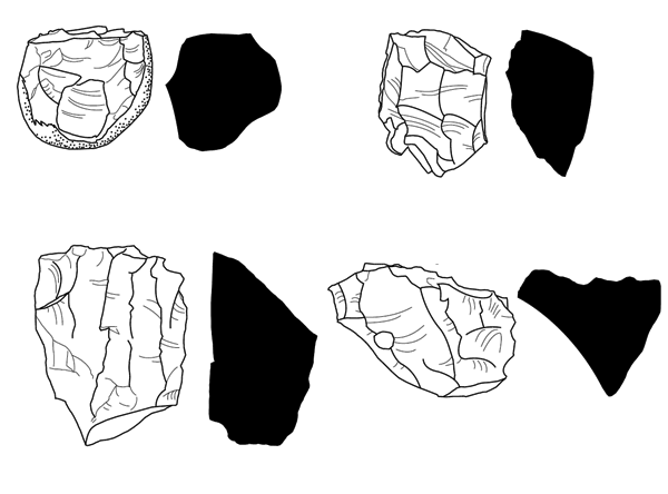
Prehistoric communities of the River Dee: Mesolithic and other lithic scatter sites of central Deeside, Aberdeenshire
Vol. 97 (2021)Prehistoric communities of the River Dee: Mesolithic and other lithic scatter sites of central Deeside, AberdeenshireAuthor: Caroline Wickham-Jones
Contributors: Richard Bates, Alison Cameron, Ann Clarke, Diane Collinson, Sheila Duthie, Tim Kinnaird, Gordon Noble, Irvine Ross, Heather Sabnis and Richard Tipping
Summary: This volume presents the results of archaeological fieldwork undertaken along the River Dee, Aberdeenshire, north-east Scotland, by the Mesolithic Deeside voluntary community archaeology group between 2017 and 2019. A total of 42 fields were investigated, from which over 11,000 lithics were recovered, representing at least 15 archaeological sites and a span of human activity covering some 10,000 years from around 12,000 BC to c 2000 BC. Finds from the Late Upper Palaeolithic, Mesolithic, Neolithic and Bronze Age were present. Work comprised fieldwalking, test pitting, specialist analysis, and small-scale excavation. The investigation described here is significant not just for the light it throws on the early prehistoric populations along the River Dee but also for the methodology by which investigation was undertaken, as this provides a potential model for work in other areas. Both aspects are covered in the report.
The River Dee flows between postglacial gravel and sand terraces, the structure of which has played an important role for the early settlers of the area, and this is covered in some detail in order to provide the physical background framework for the sites. There are also sections on more specialised geophysical and geoscience techniques where these were undertaken, together with a summary of research on the palaeoenvironmental conditions throughout the millennia of prehistory. The artefactual evidence comprises lithic assemblages which were all catalogued as fieldwork progressed; the contents of each site are presented, together with more detailed analysis of the finds from test pitted sites. Finally, given the rich archaeological record from the area, the results of the present project are set into the wider context of the evidence for prehistoric settlement along the river, and there is consideration of future directions for further fieldwork.
While all authors have contributed to the whole volume, individual sections that present specialist work by specific teams have been attributed. The distribution maps and GIS are the work of Irvine Ross.
Dates given are calibrated BC dates. The Nethermills Farm NM4 dates are calibrated using the Oxford Radiocarbon Accelerator Unit calibration program OxCal 4 (Bronk Ramsey 2009) and their date ranges are calibrated using the IntCal13 atmospheric calibration curve (Reimer et al 2013). Optically stimulated luminescence (OSL) was used to profile sediment accumulations on some of the sites and obtain information relating to site formation, but it was not used for dating in any of the projects.
Locations: Aberdeenshire, Scotland, UK
Periods: Late Upper Palaeolithic, Mesolithic, Neolithic, Bronze Age
Keywords: lithic scatter, fieldwalking, stone tool, community archaeology
This work is licensed under a Creative Commons Attribution-NonCommercial 4.0 International Licence.
-
‘A home by the sea’: the excavation of a robust Mesolithic house of the late 9th millennium BC at East Barns, East Lothian
Vol. 96 (2021)‘A home by the sea’: the excavation of a robust Mesolithic house of the late 9th millennium BC at East Barns, East Lothian
Authors: Rob Engl and John Gooder
Contributors: Clare Ellis, Randolph Donahue and Adrian Evans
Summary: In 2001 excavation works undertaken in advance of quarrying at East Barns, East Lothian (NGR: NT 7121 7686), revealed the substantial remains of a robust Mesolithic house structure, securely dated to the late 9th millennium BC. The house was situated within a large, natural hollow whose gradual infilling had effectively sealed the archaeological deposits. The house consisted of a sub-circular sunken floor with the remains of a westfacing entrance and two concentric angled post rings, suggesting episodes of replacement if not actual rebuilding. The remains of interior furniture were also recorded in the form of post holes, a platform, and three probable hearth features. A charred deposit of occupation debris rich in lithics sealed many of the structural features around the internal perimeter of the house. The distribution of this deposit appeared to reflect informal refuse toss/drop zones formed during the occupation of the structure and suggests some form of internal spatial organisation.
The house at East Barns joins an increasing group of substantial analogous sites related to Early Mesolithic activity in Scotland and northern England. These substantial house sites reflect increasing socio-economic, cultural and chronological complexity during the Mesolithic. As such the site allows provisional hypotheses to be formed about the scale and nature of Early Mesolithic social and economic adaptation around the North Sea Basin.
Locations: East Lothian, Scotland, UK
Periods: Mesolithic
Keywords: prehistoric structure, lithics, chert, chalcedony, blade, scraper, social adaptation, economic adaptation
This work is licensed under a Creative Commons Attribution-NonCommercial 4.0 International Licence.

