
Archives - Page 4
-
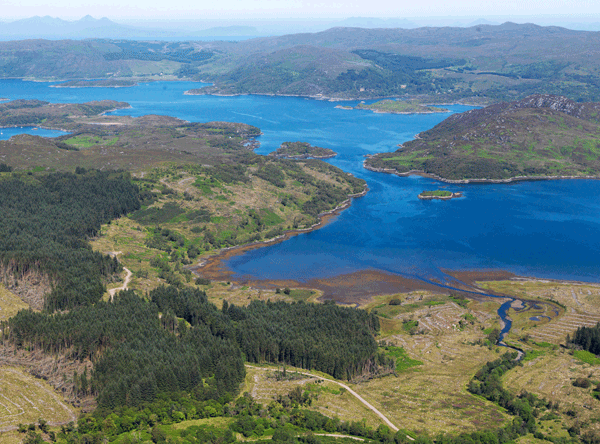
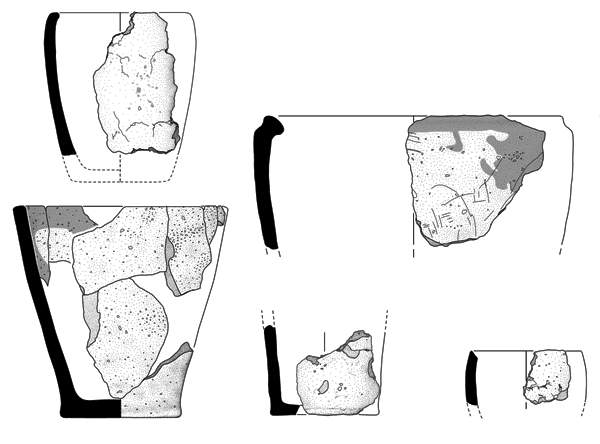
Mesolithic and later activity at North Barr River, Morvern
Vol. 84 (2019)Mesolithic and later activity at North Barr River, Morvern
Author: Gavin MacGregor
Contributors: Alistair Beckett, Ann Clarke, Nyree Finlay, David Sneddon and Jennifer Miller
Summary: At North Barr River, Morvern (NGR: NM 61430 57082), inspection of forestry planting mounds on a raised beach terrace identified a chipped stone assemblage associated with upcast deposits containing charcoal. An archaeological evaluation of the site, funded by Forestry Commission Scotland, sought to better understand the extent and character of this Mesolithic and later prehistoric lithic scatter. The lithic assemblage is predominantly debitage with some microliths and scrapers. The range of raw materials including flint, Rùm bloodstone and baked mudstone highlights wider regional networks. Other elements, including a barbed and tanged arrowhead, belong to later depositional episodes. Two mid-2nd millennium BC radiocarbon dates were obtained from soil associated with some lithics recovered from a mixed soil beneath colluvial deposits. The chronology of a putative stone bank or revetment is uncertain but the arrangement of stone may also date to the 2nd millennium BC.
Keywords: chipped stone assemblage, lithic scatter, flint assemblage, arrowhead, charcoal-burning platform, blade
Location: Highland, Scotland, UK
Periods: Mesolithic, later prehistoric

This work is licensed under a Creative Commons Attribution-NonCommercial-NoDerivatives 4.0 International Licence.
-
The changing face of industry in west Edinburgh
Vol. 85 (2019)The changing face of industry in west Edinburgh
Authors: Laura Bailey and Morag Cross
Summary: Excavations on a site at 19 West Tollcross, Edinburgh (NGR: NT 2466 7276), produced evidence of activity in the area from the medieval period to the 20th century. The medieval remains are likely to relate to activity on the periphery of a settlement in the hinterland of Edinburgh, thus confirming the archaeological potential of settlements now subsumed under the modern city. Excavation through the deep stratigraphy, when supplemented with documentary evidence, offered a glimpse into evolution of the area from an ‘agricultural landscape’ to an ‘industrial’ area, constantly being transformed in line with contemporary technological innovations. More recent remains associated with Lochrin Distillery, slaughterhouses, Edinburgh Ice and Cold Storage Company’s unit, an ice rink and a garage were uncovered.
Keywords: Lochrin distillery, slaughterhouse, cold store, ice rink
Location: Edinburgh, Scotland, UK
Periods: medieval, modern, 12th century, 20th century

This work is licensed under a Creative Commons Attribution-NonCommercial-NoDerivatives 4.0 International Licence.
-
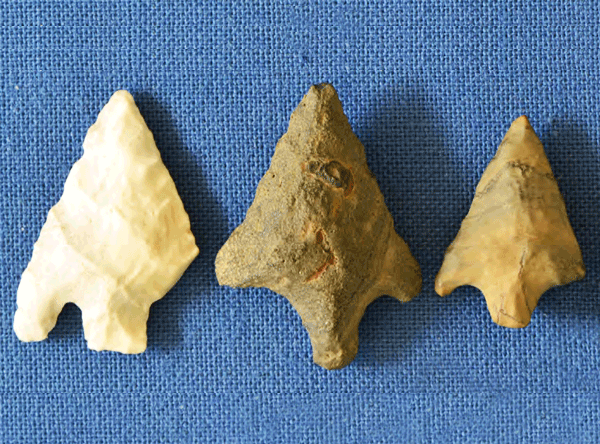
Knappach Toll, Balbridie: a late 3rd-millennium BC Beaker burial on Deeside, Aberdeenshire
Vol. 83 (2019)Knappach Toll, Balbridie: a late 3rd-millenium BC Beaker burial on Deeside, Aberdeenshire
Authors: Olivia Lelong
Contributors: Iraia Arabaolaza, Torben Bjarke Ballin, Jane Evans, Richard P Evershed, Susanna Kirk, Angela Lamb, Dawn McLaren, Lucija Šoberl and Neil Wilkin
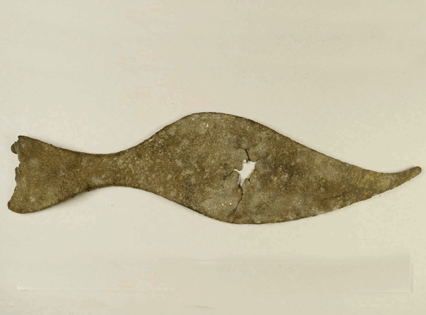
Summary: A short cist discovered during ploughing at Knappach Toll on Balbridie Farm, Aberdeenshire (NGR: NO 7369 9595) held the remains of an adult accompanied by a Beaker, fragments of a copper awl and 11 struck flints. Little survived of the skeleton except for cranial fragments, but these indicate that the person had been placed with the head to the west, with the artefacts also at that end. While the sex of the person is indeterminate, with the single surviving sexual dimorphic trait suggesting a male, the position of the body and the presence of the awl are more usually indicative of a female. Radiocarbon dating shows that the person died between 3775±35 years BP (SUERC-30852) and 2330–2040 cal BC (95.4% probability). Stable isotope analysis indicates that he or she grew up on basalt geology, like that of the region, or on chalk. Residue analysis of the Beaker has established that it had held ruminant animal fat such as butter or milk, probably for some time, and some of the flint pieces had been lightly used. The composition and constituents of the burial suggest links between north-east Scotland and East Yorkshire. They also evoke the cultural practices that were spreading across eastern Britain in the later 3rd millennium BC through the mechanisms of cultural transmission and migration.
Keywords: Beaker, Cist, Burial, Religious ritual, funerary, lithics
Location: Aberdeenshire, Scotland, UK
Period: Bronze Age

This work is licensed under a Creative Commons Attribution-NonCommercial-NoDerivatives 4.0 International Licence.
-
Excavation of a double-ditched enclosure at Winchburgh, West Lothian
Vol. 82 (2019)Excavation of a double-ditched enclosure at Winchburgh, West Lothian
Author: Gary Savory
Contributors: Mike Cressey, Clare Ellis, Mhairi Hastie, Fraser Hunter and Jennifer Thoms
Summary: A sub-circular double-ditched enclosure, visible as a cropmark on aerial photographs, was excavated at Winchburgh, West Lothian (NGR: NT 0909 7547) in 2013. The enclosure had an inner ditch with two possible entrances and an intermittent outer ditch. The inner ditch measured up to 4.65m wide and survived to a maximum depth of 1.4m. Artefactual and ecofactual assemblages were limited, with the most significant finds being evidence of shale working. Soil micromorphological analysis indicates that both ditches silted up gradually, with their fills derived from re-deposited upcast as well as soil eroding from the surroundings. Radiocarbon dates from waterlogged wood and animal bone found within the ditch fills produced a date range of 1608–204 BC. The paucity of material makes it difficult to be certain of the date and function of the enclosure.
Keywords: circular enclosure, ditch, jewellery, glass bead, animal remains
Location: West Lothian, Scotland, UK
Periods: Bronze Age, Iron Age

This work is licensed under a Creative Commons Attribution-NonCommercial-NoDerivatives 4.0 International Licence.
-
Siller Holes, West Linton: a medieval lead mining site
Vol. 81 (2019)Siller Holes, West Linton: a medieval lead mining site
Author: Valerie E Dean
Contributors: Carol Christiansen, Thea Gabra-Sanders, Anita Quye, Clare Thomas and Maureen Young
Summary: Lead ore (galena) had been extracted from the site of Siller Holes, West Linton (NGR: NT 145 533), from medieval times if not earlier; there, according to tradition, silver was refined from the lead (Pb). Creation of a pond at the foot of Lead Law produced large quantities of textiles, leather and pottery which could be dated to the 12th to 14th centuries; lead, slag and ore were also recovered. As there is no documented reference to the site until the late 16th century, it has not yet been established who was exploiting the minerals.
Keywords: organic material, inorganic material, textiles, pottery sherd
Location: Scottish Borders, Scotland, UK
Period: medieval

This work is licensed under a Creative Commons Attribution-NonCommercial-NoDerivatives 4.0 International Licence.
-
A Bronze Age barrow cemetery and a medieval enclosure at Orchardfield, East Linton, East Lothian
Vol. 80 (2018)A Bronze Age barrow cemetery and a medieval enclosure at Orchardfield, East Linton, East Lothian
Author: Magnus Kirby
Contributors: Sue Anderson, Ann Clarke, Michael Cressey, Clare Ellis, Mhairi Hastie and Melanie Johnson
Summary: Three ring-ditches, interpreted as a Bronze Age barrow cemetery, and a large ditched enclosure of likely medieval date were excavated at East Linton (NGR: NT 588 771) in advance of residential development. Cremation burials were recovered from all three of the ring-ditches, from their upper ditch fills and from a central pit in one of the ring-ditches. Also mixed into the fills were sherds of pottery, a few lithics, and two stone grinders/rubbers. A large pit close to one of the ring-ditches, which may have been used to dispose of the residue ash from one or more funeral pyres, was also excavated and provides an insight into the wider ritual activity taking place on or near the site. To the east of the barrow cemetery, a meandering length of ditch is considered to be medieval in date and probably forms an enclosure. Radiocarbon determinations produced Middle Bronze Age dates for samples of cremated human bone, with charred grain producing Iron Age and medieval dates.
Keywords: ring ditch, barrow cemetery, pottery sherd, lithic implement, stone polisher, organic material
Location: East Lothian, Scotland, UK
Periods: Bronze Age, medieval

This work is licensed under a Creative Commons Attribution-NonCommercial-NoDerivatives 4.0 International Licence.
-
Excavations by Gogar Church, Nether Gogar, Edinburgh
Vol. 79 (2018)Excavations by Gogar Church, Nether Gogar, Edinburgh
Contributors: Torben Bjarke Ballin, Beverley Ballin Smith, Donal Bateson, Dennis Gallagher, Richard Jones, Susan Ramsay and Catherine Smith
Summary: This report records the results of an excavation of a medieval settlement next to Gogar Church (NGR: NT 16827 72540) that was discovered within the construction corridor of the Edinburgh Tram line. The remains relate to the medieval village of Nether Gogar and date from the 11th to the 15th century, although later material was also recovered. The results of this work complement previous work on the site of Nether Gogar (Morrison et al 2009) and add to the growing evidence of medieval rural settlement in the Edinburgh area.
Keywords: organic material, corn drying kiln, Churchyard, ditch, coin, jewellery, millstone (smoking), cobbled surface, cereal grain, church, animal tooth, cobbled road, pottery sherd, animal bones
Period: medieval
Location: Edinburgh, Scotland, UK

This work is licensed under a Creative Commons Attribution-NonCommercial-NoDerivatives 4.0 International Licence.
-
The excavation of a medieval burgh ditch at East Market Street, Edinburgh: around the town
Vol. 78 (2018)The excavation of a medieval burgh ditch at East Market Street, Edinburgh: around the town
Contributors: Anne Crone, George Haggarty, Dawn McLaren, Jackaline Robertson, Penelope Walton-Rogers and Clare Thomas
Summary: In 2015 excavation works undertaken in preparation for a new hotel development at East Market Street, Edinburgh (NGR: NT 26242 73758), encountered the remains of a substantial ditch feature likely relating to previously excavated ditches in the medieval burghs of Edinburgh and Canongate. A substantial stratified artefact assemblage including both animal bone and ceramics was recovered and the waterlogged deposits in the base of the ditch also offered the opportunity for macroplant analysis. These waterlogged deposits afforded the preservation of artefacts including a textile garment, the first of its kind in the British Isles, and leather shoe soles boasting slender waists and turned out, pointed toes. These finds were both attributed to the 14th to 15th centuries, contributing to a vivid picture of the inhabitants of Edinburgh and Canongate in the medieval period. Analysis of both the artefact and ecofact assemblage revealed two phases of use, from the construction of the ditch in the late 12th–13th century to its eventual disuse in the latter half of the 15th century.
Keywords: Footwear, Rim Sherd, Textile, Ditch, Burgh, Ceramic, Animal Bones, Organic Material
Period: medieval
Location: Edinburgh, Scotland, UK

This work is licensed under a Creative Commons Attribution-NonCommercial-NoDerivatives 4.0 International Licence.
-
Neolithic and Bronze Age occupation at Meadowend Farm, Clackmannanshire: pots, pits and roundhouses
Vol. 77 (2018)Neolithic and Bronze Age occupation at Meadowend Farm, Clackmannanshire: pots, pits and roundhouses
Contributors: Laura Bailey, Torben Bjarke Ballin, Lucy Cramp, Sarah-Jane Haston and Scott Timpany
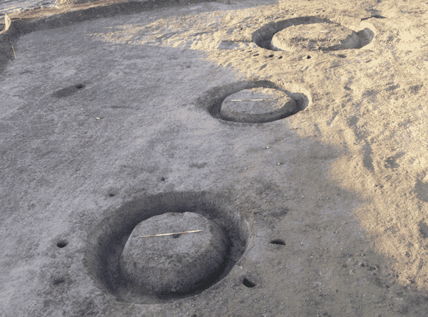
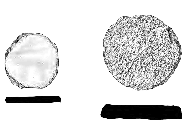
Summary: The excavations at Meadowend Farm, Clackmannanshire (NGR: NS 9280 9040) produced evidence for occupation at various times between the Early Neolithic and the Middle to Late Bronze Age. Significantly, it yielded the largest and best-dated assemblage of Middle Neolithic Impressed Ware yet encountered in Scotland, comprising at least 206 vessels. Episodes of Early to (pre-Impressed Ware) Middle Neolithic activity were represented by pits and post holes scattered across the excavated areas, some containing pottery of the Carinated Bowl tradition and some with charred plant remains; three blades of pitchstone and one of non-local flint were also found. The phase of activity associated with the Middle Neolithic Impressed Ware pottery (c 3350‒3000 cal BC) is represented mostly by clusters of pits, some containing hearth waste and/or charcoal, charred cereal grain and burnt hazelnut shell fragments. A stone axehead and a broken roughout for an axe- or adze-head were associated with this phase of occupation. There then appears to have been a hiatus of activity of around a millennium before occupation resumed. One Early Bronze Age structure and pits dating to around 2000 cal BC (plus undated pits containing possible Beaker pottery) were succeeded by four Early to Middle Bronze Age roundhouses dating to c 1750‒1300 cal BC and a large pit containing parts of at least 37 pots, and subsequently by two large double-ring roundhouses, an oval building, and ancillary structures and features dating to the Middle to Late Bronze Age, c 1300‒900 cal BC. There is also evidence suggesting low level activity during the Iron Age, plus two medieval corn-drying kilns. Environmental evidence indicates cereal growing from the earliest period, and local woodland management. This publication focuses on the Neolithic and Bronze Age periods and discusses the significance of this site for our understanding of these periods, and particularly for the Middle Neolithic, in Scotland.
Keywords: Roundhouse, Rim Sherd, Blade, Axehead, Bowl, Carinated Bowl, Pottery Sherd, Impressed Ware
Periods: Early Bronze Age, Middle Neolithic, Early Neolithic, Bronze Age, Late Bronze Age, Middle Bronze Age, Late Neolithic
Location: Clackmannanshire, Scotland, UK

This work is licensed under a Creative Commons Attribution-NonCommercial-NoDerivatives 4.0 International Licence.
-
Barabhas Machair: surveys of an eroding sandscape
Vol. 76 (2018)Barabhas Machair: surveys of an eroding sandscape
Contributors: Mark Elliot, Torben Bjarke Ballin and Trevor Cowie
Summary: The townships of Barabhas are on the west coast of the Isle of Lewis, in the Outer Hebrides between the blanket bog of Barabhas Moor to the east, and machair and the Atlantic Ocean to the west. The Barabhas Machair (centre NGR: NB 351 513) has been eroding for at least a century, and of archaeological interest for nearly as long. Survey and excavations over the last 40 years have revealed settlements from the Early Bronze Age to the present day, in a landscape that has been used and reused. This paper is the first of a series presenting the results of this fieldwork, reporting on the results of the surveys and on the results of initial documentary research, and has been produced as part of a wider post-excavation project supported by Historic Environment Scotland.
Keywords: Lithic Scatter, Archaeological Landscape, Croft, Cemetery, Wall, Beaker
Periods: Late Iron Age, Early Iron Age, Late Bronze Age, post-medieval, Early Bronze Age
Location: Western Isles, Scotland, UK

This work is licensed under a Creative Commons Attribution-NonCommercial-NoDerivatives 4.0 International Licence.
***
[Gaelic]
Tha bailtean Bharabhais air costa an iar Eilean Leòdhais anns na h-Eileanan an Iar, eadar brat- boglaich Mòinteach Bharabhais chun ear, agus a’ mhachair agus An Cuan Siar air an taobh siar. Tha Machair Bharabhais (meadhan NB 351 513) air a bhith ga bleith fad co-dhiù ceud bliadhna, agus tha ùidh air a bhith aig arc-eòlaichean anns a’ mhachair cha mhòr a cheart cho fada. Tha sgrùdaidhean agus cladhachaidhean thairis air an dà fhichead bliadhna mu dheireadh air tuineachaidhean fhoillseachadh, bho thràth Linn an Umha chun an latha an-diugh, ann an dealbh-tìre a tha air a bhith air a chleachdadh agus air ath-chleachdadh. ’S e seo a’ chiad artaigil ann an sreath a bhios a’ taisbeanadh toraidhean na h-obrach seo, a’ toirt cunntas air toraidhean nan sgrùdaidhean agus toraidhean ciad rannsachadh aithriseach. Tha iad air an cruthachadh mar phàirt de phròiseact iar-cladhach aig a bheil taic bho Alba Aosmhor.

