
Archives - Page 6
-
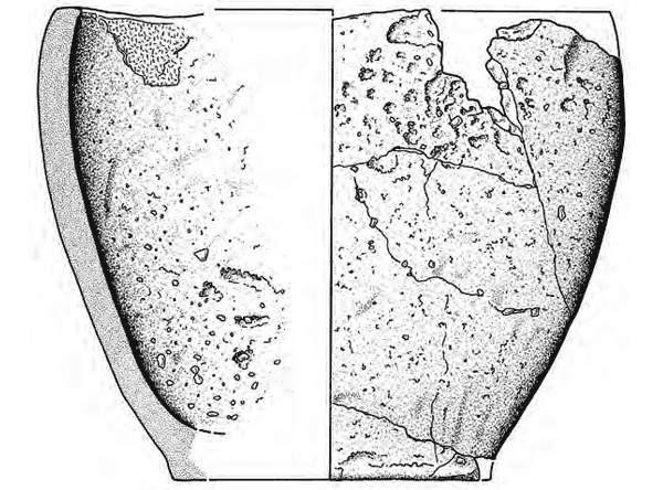
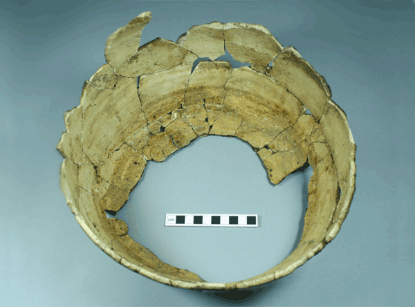
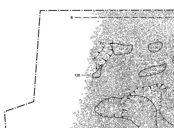
A medieval farmstead at Laigh Newton North-West, East Ayrshire
Vol. 65 (2017)A medieval farmstead at Laigh Newton North-West, East Ayrshire
Contributors: Beverley Ballin Smith, Susan Ramsey and Bob Will
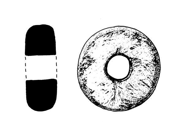
Summary: Excavations at Laigh Newton North-West Ayrshire (NGR: NS 5937 3684) in advance of quarrying revealed a rare late medieval farmstead consisting of a palisaded enclosure, four sunken stone- and turf-built buildings, one of which maybe a charcoal kiln, two possible timber-built structures and drainage ditches. The pottery and radiocarbon dates indicate that the site was occupied in the 14th–15th centuries. It is thought that this site belonged to the farm of Newton, which was first documented in the late 14th century within the parish of Galston. At that time the parish of Galston belonged to the Lockhart family. The site probably went out of use in the 16th or 17th century as a result of a change of ownership and the increased commercialisation of farming practice. As a result the structures were demolished or allowed to decay, the ditches were filled in and the land turned over to arable.
Keywords: Farmstead, Charcoal kiln, Sherd, Enclosure, Palisade
Period: medieval
Location: East Ayrshire, Scotland, UK

This work is licensed under a Creative Commons Attribution-NonCommercial-NoDerivatives 4.0 International Licence.
-
Relieving floods, revealing history: Early Prehistoric activity at Knocknagael Farm, Inverness
Vol. 64 (2016)Relieving floods, revealing history: Early Prehistoric activity at Knocknagael Farm, Inverness
Contributors: Torben Bjarke Ballin, Beverley Ballin Smith and Susan Ramsay
Summary: A programme of archaeological work prior to the construction of a flood-relief channel at Knocknagael Farm, south-west of Inverness (NGR: NH 656 414), revealed a series of prehistoric features including pits, hearths, fire-spots and possible structural features. Finds included sherds from a Neolithic bowl and a Bronze Age cordoned urn. Palaeo-botanical remains were present in many features and included the carbonised remains of cereal grains including naked six-row barley and spelt. Radiocarbon dating revealed that activity at the site ranged from the 7th millennium BC to the 1st millennium AD. This is one of the earliest dates yet obtained from the Culduthel valley, which has already produced much evidence of prehistoric activity including the high-status Iron Age site of Culduthel Farm (Highland HER MHG49950).
Read the full account of the excavations at Culduthel in Culduthel: An Iron Age Craftworking Centre in North-East Scotland
Keywords: bowl, pits, hearths, spelt, urn, barley, sherds, cereal grains
Periods: Iron Age, Neolithic, Bronze Age, early prehistoric
Location: Highland, Scotland, UK

This work is licensed under a Creative Commons Attribution-NonCommercial-NoDerivatives 4.0 International Licence.
-
Excavation of two Early Bronze Age short cists and a prehistoric pit at Lindsayfield, near Stonehaven, Aberdeenshire
Vol. 63 (2016)Excavation of two Early Bronze Age short cists and a prehistoric pit at Lindsayfield, near Stonehaven, Aberdeenshire
Contributors: Sue Anderson, Torben Bjarke Ballin, Mhairi Hastie and Alison Sheridan
Summary: Two short cists of Early Bronze Age date, containing prehistoric flint artefacts and shale/cannel coal beads, were discovered during topsoiling operations for the Aberdeen to Lochside Natural Gas Pipeline, to the south of Lindsayfield, near Stonehaven, Aberdeenshire (NGR: NO 8195 8412). Cremated human bone from one of the cists was radiocarbon dated to the first half of the 2nd millennium BC. A pit which contained broadly contemporary prehistoric flint artefacts and pottery was found nearby.
Keywords: pottery, coal beads, pit, flint artefacts, human bone
Periods: prehistoric, Early Bronze Age
Location: Aberdeenshire, Scotland, UK

This work is licensed under a Creative Commons Attribution-NonCommercial-NoDerivatives 4.0 International Licence.
-
Ben Lawers, an archaeological landscape in time: results from the Ben Lawers Historic Landscape Project, 1996–2005
Vol. 62 (2016)Ben Lawers, an archaeological landscape in time: results from the Ben Lawers Historic Landscape Project, 1996–2005
Contributors: J D Bateson, Ann Clarke, Sue Constable, Adrian Cox, George Dalgleish, John S Duncan, Nyree Finlay, Craig Frew, George Haggarty, Janet Hooper, Lorna Innes, Joanne T McKenzie, Kirsteen McLellan, Jennifer Miller, Robin K Murdoch, Effie Photos-Jones, Susan Ramsay, Julie Roberts, Ingrid Shearer, Alison Sheridan, Ian A Simpson, Ronan Toolis, Margaret Watters, Robert S Will and Lyn Wilson
Summary: This volume presents the results of archaeological investigations between 1996 and 2005, carried out as part of the Ben Lawers Historic Landscape Project, a multi-disciplinary project based on north Loch Tayside in the Central Highlands of Scotland (NGR: NN 63763 41298). Archaeological surveys and excavations formed the core of the Ben Lawers Project, but many other disciplines also contributed to researching this landscape. Some of these partner projects are reported here, while others have been presented elsewhere (Tipping et al 2009), and some have formed part of doctoral research projects (Watters 2007). The results of the 13 field seasons, particularly the nine evaluation and excavation seasons, together with the results of the partner projects, specialist studies and scientific analyses, have provided a body of evidence which permits the story of the land of Lawers to be told. The historical continuum in that story can be used to curate and manage this landscape for generations to come.
Keywords: scientific analyses, lithics, hut circle, chambered cairn, round barrow, crannog, ring-ditch house, cist, inhumation, cemetery, shieling hut, manor house, castle, tower house, assemblage, Beaker, sherds, rotary quern
Periods: Early Prehistoric, Mesolithic, Neolithic, Iron Age, early medieval, medieval, post-medieval
Location: Perth and Kinross, Scotland, UK

This work is licensed under a Creative Commons Attribution-NonCommercial-NoDerivatives 4.0 International Licence.
-
Prehistoric settlement patterns in the north-east of Scotland: excavations at Grantown Road, Forres 2002–2013
Vol. 61 (2016)Prehistoric settlement patterns in the north-east of Scotland: excavations at Grantown Road, Forres 2002–2013
Contributors: David Dungworth, Clare Ellis, Rob Engl, Rachael Ives, Dawn McLaren and Jackaline Robertson
Summary: The commercial development of the north-east of Scotland has resulted in a huge influx of new information on the prehistoric and Early Historic occupation of the area. A series of cropmarks investigated at Grantown Road, Forres (NGR: NJ 0263 5740) between 2002 and 2013 has confirmed the presence of an extensive Iron Age settlement and revealed new evidence for activity from the Neolithic to the Early Historic period. The Iron Age settlement is represented by a variety of building types including ring-ditch, ring-groove and post-ring structures, in association with four-post structures, a souterrain and metalworking furnaces. Although the Neolithic, Bronze Age and Early Historic periods are not so well represented they nonetheless have provided evidence for the occupation of the area. The artefactual assemblage includes Neolithic and Bronze Age ceramic and coarse stone and Iron Age material relating to metalworking.
Keywords: metalworking, ceramic, settlement, stone, cropmarks
Periods: Bronze Age, prehistoric, Iron Age, Neolithic
Location: Moray, Scotland, UK

This work is licensed under a Creative Commons Attribution-NonCommercial-NoDerivatives 4.0 International Licence.
-
Multi-period activity, the European Marine Science Park, Dunstaffnage, Argyll
Vol. 60 (2016)Multi-period activity, the European Marine Science Park, Dunstaffnage, Argyll
Contributors: Derek Hamilton, Susan Ramsay, Angela Boyle, Anne MacSween, Gemma Cruickshanks and Torben Bjarke Ballin
Summary: Excavation in advance of development of the European Marine Science Park at Dunstaffnage in Argyll (NGR: NM 87878 34063) revealed multi-phased activity from the Neolithic into the Early Historic period. An irregular row of firepits, interpreted as funerary pyres, was orientated east–west and incorporated an infant inhumation and a cobble path. Dating of charcoal revealed that the fire-pits were probably in use for a number of generations during the Late Iron Age. The fire-pits were located on the edge of wet ground and it is postulated that these were deliberately located on what may have been perceived as a liminal boundary to aid passage into the afterlife. Activity shifted to the drier ground in the Early Historic period, late 7th to 9th century, in the form of an extended farmstead within which barley and oats were being dried in a kiln. Evidence for possible barns and/or houses survives in the form of a post-hole structure, a post-built wattle and daub structure, at least one basket pit boiler and a number of cobble hearths. One pit contained ten metal artefacts thought to be derived from agricultural implements or a dismantled structure. The duration of use of the farmstead appears to have been relatively short and it may have been seasonally occupied.
Keywords: inhumation, farmstead, cobble path., basket pit, cobble hearths, charcoal, post-hole structure, funerary
Periods: Early Historic, late 7th century, 8th century, 9th century, Late Iron Age, Neolithic
Location: Argyll and Bute, Scotland, UK

This work is licensed under a Creative Commons Attribution-NonCommercial-NoDerivatives 4.0 International Licence.
-
A Roman road runs through it: excavations at Newbridge, Edinburgh
Vol. 59 (2016)A Roman road runs through it: excavations at Newbridge, Edinburgh
Contributors: Nick Johnstone, George Haggarty and Jackaline Robertson
Summary: Excavations in advance of a phased commercial development at Newbridge, Edinburgh (NGR: NT 121 733) have revealed a palimpsest of activity spanning the Middle Bronze Age to the medieval period. There was a scatter of domestic settlement in the Middle Bronze Age and pre-Roman Iron Age, together with small ring-groove features which may be the remnants of a barrow cemetery forming part of a later prehistoric ritual landscape centred on Huly Hill. Perhaps the most significant discovery of these excavations is the identification of a section of Roman road which probably represents the westward extension of Dere Street linking Inveresk and Carriden. Its discovery provides solid evidence for the routeway that the milestone at Ingliston and the temporary camps at Gogar have always intimated. Finally, the area was farmed in the medieval period, the associated settlement probably lying to the north of the excavated area. The dating evidence suggests two distinct phases of activity, in the 11th to 12th centuries and in the 13th to 14th centuries, a pattern reflected in other medieval settlement in the Lothians.
Keywords: barrow, settlement, ritual, road
Periods: prehistoric, Roman, Middle Bronze Age, pre-Roman Iron Age
Location: Edinburgh, Scotland, UK

This work is licensed under a Creative Commons Attribution-NonCommercial-NoDerivatives 4.0 International Licence.
-
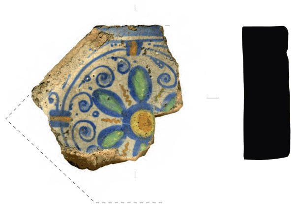
Excavations at Jeffrey Street, Edinburgh: the development of closes and tenements north of the Royal Mile during the 16th–18th centuries
Vol. 58 (2014)Excavations at Jeffrey Street, Edinburgh: the development of closes and tenements north of the Royal Mile during the 16th–18th centuries
Summary: Excavations on the site of a former tannery to the rear of Edinburgh's High Street (NGR: NT 260 737) produced evidence for the infilling of medieval burgage plots from the 16th century onwards. Walls defining a terrace and a burgage plot boundary suggest a considerable investment in at least some of the backlands during the medieval period, but these structures later went out of use, corresponding to a widely documented decline in Scottish towns during the 14th century. During the late 16th century, substantial buildings with cellars on either side of a paved close represent the first appearance of the multi-storey tenement buildings that characterise much of the Old Town. These buildings provide the basis for a discussion of the character of urbanisation in late 16th- and early 17th-century Edinburgh. The cellars were demolished and backfilled with refuse at different dates between the 1640s and 1740s. Finds from these refuse deposits are highly significant as a sample of changing consumption patterns during this period. During the 18th century the area appears to have declined in status and taken on a more industrial character; later, a tannery was established on part of the site by the 1830s, which expanded to cover much of the site by the 1880s.
Keywords: boundary, Walls, tannery, cellars, Burgage, Plots, Pits, Buckle, Pottery, Pipes, Exotic Plant Remains, Charcoal, Carbonised Plant Remains, Barley, Dutch Redware, Redware, Sheep, Cattle, Bird Bones, Domestic Chicken, Mouse, Pig Dog Cat Rabbit, Fish Bones, Domestic Bird, Bones, urbanisation
Periods: Roman, medieval, 16th century, 17th century, 18th century
Location: Edinburgh, Scotland, UK
-
Excavation across the Dere Street Roman Road at Dun Law, Scottish Borders
Vol. 57 (2014)Excavation across the Dere Street Roman Road at Dun Law, Scottish Borders
Contributors: Clare Ellis, Jacqueline Huntley and Robert McCulloch
Summary: Dere Street Roman Road was strategically important to the Roman army. It was built in the late 1st century ad to enable the advance of the Roman Army, commanded by Agricola, into the hostile territories of what is now Scotland. This eastern arterial road linked the Roman legionary forts of Eburacum (York) and Inchtuthil near Perth, and continued to be used through the medieval period, its longevity of use standing as a testament to Roman engineering and road construction. In 2007 an archaeological excavation made an exciting discovery which sheds new light on construction techniques employed by Agricola’s legionnaires and demonstrates their adaptive ability to use whatever local resources were at hand to engineer a solution for crossing difficult terrain. As an archaeological response to a proposal to extend the existing Dun Law Windfarm, excavations were conducted by CFA Archaeology Ltd across what was believed to be the course of Dere Street running across Dun Law, a prominent, but wet and boggy, hillside in the Scottish Borders (NGR: NT 4643 5663). The excavations discovered a surviving section of the road, which at that point traversed a palaeochannel by means of a latticework of logs and a mat of branchwood.
Keywords: Road, Legionary Forts, Pollen, Micromorphology, Radiocarbon Dating, Organic Soils
Periods: Roman, medieval
Location: Scottish Borders, Scotland, UK
-
Excavations in the Canongate Backlands, Edinburgh
Vol. 56 (2013)Excavations in the Canongate Backlands, Edinburgh
Contributors: Clare Ellis, George Haggarty, Andrew Heald, Stuart Campbell, David Henderson, Dennis B Gallagher, Nicholas N McQ Holmes, Jill Turnbull and Patrice Vandorpe
Summary: The following paper presents the results of two excavations undertaken in 1999 and 2000 within parts of the World Heritage Site of the Old Town of Edinburgh and the Canongate (NGR: NT 2665 7377). Excavation at Plot N of the Holyrood North Re-Development Project, Holyrood Road, unearthed evidence of medieval boundary works (including a possible 12th-century burgh ditch), a 17th-century well, a medieval graindrying kiln, refuse pits, drainage features and post-medieval cultivation soils. Excavation alongside Calton Road revealed evidence of medieval/post-medieval property divisions, cultivation soils and quarry pits. Both sites yielded significant artefact assemblages.
Keywords: boundary, quarry pits, pits, graindrying kiln, ditch, castle, Vessel glass, Pottery, Ceramic Material, Window Glass, Animal Bone
Periods: medieval, post-medieval
Location: Edinburgh, Scotland, UK

