
Archives - Page 5
-
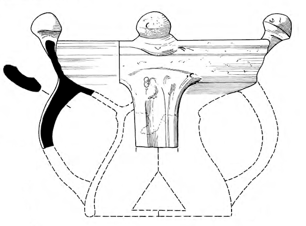
Fluid identities, shifting sands: Early Bronze Age burials at Cnip Headland, Isle of Lewis
Vol. 75 (2018)Fluid identities, shifting sands: Early Bronze Age burials at Cnip Headland, Isle of Lewis
Contributors: Thomas Booth, Jane Evans, Derek Hamilton, Brendan J Keely, Maureen Kilpatrick, Susanna Kirk, Angela Lamb, Dawn McLaren, Susan Ramsay and Alison Sheridan
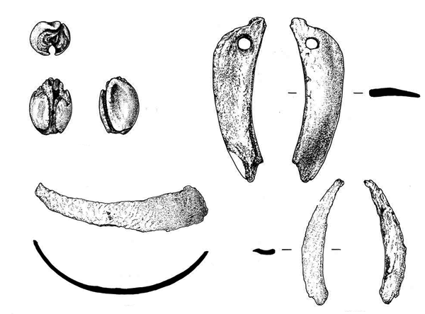
Summary: Excavations in 2009 and 2010 on Cnip Headland, Isle of Lewis (NGR: NB 0998 3656) investigated three different burials in shallow pits and on a kerbed mound, containing the inhumed remains of at least nine individuals in both articulated and disarticulated states. Bone histology analysis indicates that the bodies of all but one (a stillborn infant) were allowed to decay and become partly or wholly skeletonised before being buried at this spot. Worn jet beads, a copper-alloy awl and pieces of boar tusk and marine ivory accompanied some of the remains. The burials lay around a cairn, which previous excavations have shown was built in the 3rd millennium BC and then rebuilt twice, with both cremated and unburnt human remains incorporated in it. Another inhumation burial in a stone-lined pit close to the cairn was excavated in the 1990s. Bayesian analysis indicates that the cairn’s first reconstruction and the placing of human remains around it took place over a period of up to 150 years between 1770 and 1620 BC. The headland’s long use for rites involving human remains illuminates relationships between living communities and their lineages in Early Bronze Age north-west Scotland.
Keywords: Burial Cairn, Animal Tooth, Burial, Awl, Bead
Period: Early Bronze Age
Locations: Western Isles, Scotland, UK

This work is licensed under a Creative Commons Attribution-NonCommercial-NoDerivatives 4.0 International Licence.
***
[Gaelic]
Dearbh-aithne neo-sheasmhach, gainneamh ghluasadach: tiodhlacaidhean bho Tràth Linn an Umha air Rubha a’ Chnìp, Eilean LeòdhaisÙghdar: Olivia Lelong
Le cuideachadh bho: Thomas Booth, Jane Evans, Derek Hamilton, Brendan J Keely, Maureen Kilpatrick, Susanna Kirk, Angela Lamb, Dawn McLaren, Susan Ramsay and Alison Sheridan
Geàrr-chunntas: A’ cladhach ann an 2009 agus 2010 air Rubha a’ Chnìp ann an Eilean Leòdhais (NGR: NB 0998 3656), rinneadh sgrùdadh arc-eòlach air trì tiodhlacaidhean eadar-dhealaichte ann an slocan eu-domhain agus air tom cabhsaireach anns an robh iarmad daonna naoinear, cuid slàn agus cuid nam pìosan. Tha anailis hiosto-eòlach chnàimhean a’ comharrachadh gun deach leigeil le na cuirp aca seargadh gus an robh iad gu tur, no gu ìre, nan cnàimhichean, mus deach an tiodhlacadh air an làraich seo, ach a-mhàin aon neach (pàiste a bha marbh ga bhreith). Còmhla ri cuid den iarmad daonna bha grìogagan finiche ath-chaithte, brog de dh’ aloidh- copair agus pìosan de thosg tuirc agus ìbhri mara. Bha iad air an tiodhlacadh timcheall air càrn. Dhearbh cladhach a rinneadh na bu tràithe gun deach an càrn a thogail san treas linn BC agus gun deach ath-thogail dà thuras an dèidh sin, le iarmad daonna loisgte agus gun a bhith air a losgadh air a ghabhail a-steach ann. Chaidh tiodhlacadh eile ann an sloc a th’air a lìnigeadh le clachan a chladhach anns na 1990an. A rèir anailis Bayeseach tha e coltach gun deach a’ chiad ath-thogail a dhèanamh air a’ chàrn, le iarmad daonna ga chàradh ann, thairis air ùine suas ri 150 bliadhna, eadar 1770 agus 1620 BC. Tha gu robh an rubha air a chleachdadh thairis air iomadh bliadhna airson deas-ghnàthan co-cheangailte ri bàs a’ soilleireachadh càirdeasan eadar coimhearsnachdan beò agus an sinnsearachd ann an Tràth Linn an Umha ann an ceann an iar-thuath Alba. Chaidh an obair a dhèanamh dha Alba Aosmhor fo Chùmhnant Cladhach Èiginneach Iarmaid Daonna.
-
Excavations and interventions in and around Cramond Roman Fort and annexe, 1976 to 1990
Vol. 74 (2017)Excavations and interventions in and around Cramond Roman Fort and annexe, 1976 to 1990
Contributors: Paul Bidwell, Hilary E M Cool, Alexandra Croom, Rob Engl, Kay F Hartley, Nicholas Holmes, Fraser Hunter and Felicity Wild
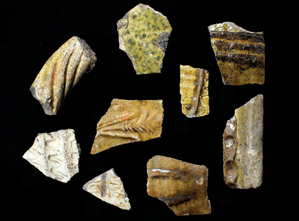
Summary: Cramond Roman Fort (NGR: NT 19032 76903) has been the focus of archaeological interest since the publication of John Wood’s history of the parish in the late 18th century, with a floruit of activity in the latter half of the 20th century. Playing an important part in this volume of work have been the excavations led by the late Mr Charlie Hoy (died 1991), an Edinburgh amateur archaeologist working principally with the Edinburgh Archaeological Field Society and latterly on his own. His excavations have recovered a wide range of evidence from the Mesolithic through the Roman and medieval periods up to the post-medieval development of Cramond House Estate. Hoy’s investigations have been hugely important to our understanding of the Roman fort’s associated annexe/extramural settlement, in particular providing new evidence for its origins in the Antonine period, and for Severan occupation, as well as uncovering a multi-phased road and associated wooden structures. In addition, the artefact assemblage further adds to the corpus from the site and includes an internationally significant sword pendant belonging to a beneficiarius (beneficiarii were troops on special service for the provincial governor) that demonstrates the presence of German troops at the fort, and perhaps hints at the presence of the emperor himself.
Keywords: Frontier Defence, Tower, Annexe, Samian, Amphora, Tile, Vessel, Coin
Periods: Mesolithic, Roman, medieval
Location: Edinburgh, Scotland, UK

This work is licensed under a Creative Commons Attribution-NonCommercial-NoDerivatives 4.0 International Licence.
-
Achanduin Castle, Lismore, Argyll: an account of the excavations by Dennis Turner, 1970–5
Vol. 73 (2017)Achanduin Castle, Lismore, Argyll: an account of the excavations by Dennis Turner, 1970–5
Contributors: Donald Bramwell, Geoffrey Collins, George Haggarty, Derek Hall, Nicholas Holmes, Andrew Jones, Barbara Noddle and Nigel Ruckley
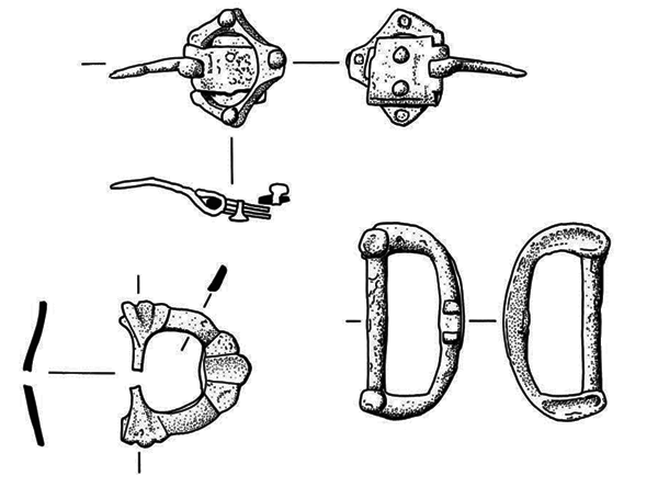
Summary: Excavations were undertaken at Achanduin Castle, Lismore, Argyll (NGR: NM 8043 3927), over six seasons from 1970 to 1975 under the direction of the late Dennis John Turner (1932–2013), henceforward referred to as DJT. Partly funded by the Society of Antiquaries of Scotland and with tools and equipment loaned by RCAHMS (now Historic Environment Scotland), the work was carried out in support of the RCAHMS’s programme of survey in the Lorn district of Argyll. Its purpose was to examine an apparently little-altered but much-ruined example of a castle of enclosure ascribable to a small but identifiably distinct group of rectangular, or near rectangular, courtyard castles. DJT concluded that it was built c 1295–1310 by the MacDougalls, and only later passed to the bishops of Argyll. The authors add their own observations on the excavations in a separate section. They note tenuous evidence for a pre-castle phase. The bulk of the report focuses on the erection and occupation of the castle, followed by abandonment, post-medieval occupation, collapse/demolition and recent times.
Keywords: castle, Pottery, Coin, Brooch, Knife, Buckle, Animal remains
Period: medieval
Location: Argyll and Bute, Scotland, UK

This work is licensed under a Creative Commons Attribution-NonCommercial-NoDerivatives 4.0 International Licence.
-
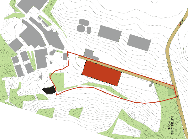
Excavations to the west of Gogar Mains, Edinburgh
Vol. 72 (2017)Excavations to the west of Gogar Mains, Edinburgh
Contributors: Torben Bjarke Ballin, Beverley Ballin Smith and Susan Ramsay
Summary: This report records the results of the excavation of a multi-period site that was discovered within the construction corridor of the Edinburgh tram line. The site is located to the west of Gogar Mains (NGR: NT 1577 7276) and to the east of the Park and Ride car park by Edinburgh Airport. It was discovered during an archaeological evaluation in 2006 along the proposed tram route. Following this, an open area excavation uncovered a range of features and structures that date from the Neolithic and Bronze Age through to the Late Iron Age and early medieval period. These features include a palisaded enclosure, two possible corn-drying kilns and a dense concentration of post-holes and pits. During the course of the tram construction programme a military pillbox next to the airport was recorded in advance of demolition (see Appendix).
Keywords: pit, corn drying kiln, post hole, palisaded enclosure
Periods: Bronze Age, early medieval, Neolithic, Iron Age
Location: Edinburgh, Scotland, UK

This work is licensed under a Creative Commons Attribution-NonCommercial-NoDerivatives 4.0 International Licence.
-
The development of Candlemaker Row, Edinburgh, from the 11th to the 20th centuries
Vol. 71 (2017)The development of Candlemaker Row, Edinburgh, from the 11th to the 20th centuries
Contributors: Morag Cross, Timothy M Mighall, Sarah-Jane Haston, Catherine Smith, Stuart Morrison and Tim Holden
Summary: Archaeological excavations and historic-building recording at the site of Greyfriars Kirkhouse, Candlemaker Row, Edinburgh (NGR: NT 25556 73371), provided a rare opportunity to investigate the history of an area within Edinburgh's Old Town. Evidence was found for unexpectedly early activity on the site from the 11th or 12th century onwards. The nature of early activity is enigmatic but the area appears to have been largely rural, at the confluence of two major cattle-droving routes into the town. Urban development came in the late 15th century, with the division of the land into burgage-plots and construction of a tenement, at which point the area seems to have been occupied by merchants and burgesses. The late 18th and early 19th centuries saw the redevelopment of the site and evidence for the use of the area as a brass foundry.
Keywords: tenement, pit, unidentified pottery, glass vessel, burgage-plots, brass foundary
Periods: medieval, late medieval, post-medieval, early modern
Location: Edinburgh, Scotland, UK

This work is licensed under a Creative Commons Attribution-NonCommercial-NoDerivatives 4.0 International Licence.
-
Excavation of prehistoric roundhouses and post-medieval kilns at Drumyocher and Hospital Shields, Aberdeenshire
Vol. 70 (2017)Excavation of prehistoric roundhouses and post-medieval kilns at Drumyocher and Hospital Shields, Aberdeenshire
Contributors: Sue Anderson, Torben Bjarke Ballin, Mike Cressey, Mhairi Hastie, Adam Jackson, Dawn McLaren and Phil Richardson
Summary: A programme of archaeological watching brief and excavation was carried out by CFA Archaeology Ltd along the route of the Aberdeen to Lochside Natural Gas Pipeline during its construction in 2004. The remains of four truncated Middle Bronze Age roundhouses, one Iron Age post-built roundhouse with a souterrain entered from the house, and two medieval or post-medieval corn-drying kilns were excavated at Drumyocher Farm, near Arbuthnott, Aberdeenshire (NGR: NO 7831 7679). An assemblage of decorated pottery was recovered, unusually for this period. The remains of three truncated probable ring-ditch roundhouses were excavated to the north-east of Hospital Shields Farm, near St Cyrus, Aberdeenshire (NGR: NO 7215 6740); these features have been radiocarbon dated to the Late Bronze Age.
Keywords: roundhouse, roundhouse, souterrain, corn drying kiln, kiln
Periods: Middle Bronze Age, Iron Age, Iron Age, medieval, late medieval
Location: Aberdeenshire, Scotland, UK

This work is licensed under a Creative Commons Attribution-NonCommercial-NoDerivatives 4.0 International Licence.
-
Discovering the King’s wall: excavations at 144–166 Cowgate, Edinburgh
Vol. 69 (2017)Discovering the King’s wall: excavations at 144–166 Cowgate, Edinburgh
Contributors: Stephen Carter, Morag Cross, Dianne Dixon, Nicholas Holmes, Stephen Lancaster, Catherine Smith and Scott Timpany
Summary: This report details the discovery of a late medieval building and the remains of extensive walls running along the north side of Cowgate (NGR: NT 25851 73489), excavated in advance of a housing development. The wall remains were dated to the late 14th century and are believed to have been part of Edinburgh’s early town defences. Edinburgh’s medieval town wall is referred to as the ‘King’s wall’ and is linked to a James II charter of 1450. However, there are references to the King’s wall in property documents as early as 1427, indicating that a town wall had been built prior to the charter of 1450. The remains uncovered at Cowgate are likely to be part of this early town wall. It was replaced by more substantial mortared buildings at the beginning of the 17th century.
Keywords: wall, burgage plot, town defences, pottery, coin, dress and personal accessories, dress fastener, nail, spindle whorl
Periods: medieval, late medieval
Location: Edinburgh, Scotland, UK

This work is licensed under a Creative Commons Attribution-NonCommercial-NoDerivatives 4.0 International Licence.
-
Monks, priests and farmers: a community research excavation at Baliscate, Isle of Mull
Vol. 68 (2017)Monks, priests and farmers: a community research excavation at Baliscate, Isle of Mull
Contributors: Torben Bjarke Ballin, Angela Boyle, Gemma Cruickshanks, George Haggarty, Derek Hall, Derek Hamilton, Richard Jones, Anthony Krus, Kenneth Murdock and Susan Ramsay
Summary: A community research excavation centred on Baliscate on the Isle of Mull (NGR: NM 49677 54068) took place in autumn 2012. The excavation has revealed the existence of a thriving 6th-century agricultural settlement which was either adopted or replaced by a 7th-century Christian community which appears to have been a monastic establishment. The continued ecclesiastical nature of the settlement into the 9th and 10th centuries is attested by the presence of a later enclosure/vallum and a rectangular structure interpreted as a leacht. In the late 11th or early 12th century, a stone and turf bow-ended structure was built which probably functioned as a longhouse or hall. This structure was later used in the 12th century to house a large corn-drying kiln. Although no 11th- or 12th-century structures were identified adjacent to the leacht, occupation deposits were identified. Then, in the late 13th or early 14th century, a wattle and turf structure was built over these deposits and the remains of a seventh- to eighth-century cemetery. This structure burnt down and was rapidly replaced by a new stone and turf structure enclosed by a rectangular stone and turf enclosure. This is tentatively interpreted as an enclosed chapel, but the evidence is contradictory and it may have simply been an enclosed farmstead. Occupation around the site continued in one form or another until the 16th century and thereafter the site was used intermittently. The excavation has highlighted how little we know about the so-called enclosed chapel sites of Argyll and the absence of evidence for the early Christian church.
Keywords: chapel, leacht, corn drying kiln, vallum, community archaeology
Periods: Late Iron Age, early medieval, medieval, late medieval, early modern
Location: Argyll and Bute, Scotland, UK

This work is licensed under a Creative Commons Attribution-NonCommercial-NoDerivatives 4.0 International Licence.
-
Where there's muck there's money: the excavation of medieval and post-medieval middens and associated tenement at Advocate's Close, Edinburgh
Vol. 67 (2017)Where there's muck there's money: the excavation of medieval and post-medieval middens and associated tenement at Advocate's Close, Edinburgh
Contributors: Dennis Gallagher, George Haggarty, Jen Harland, Mike Roy, Dawn McLaren, Jackaline Robertson and Hugh Willmott
Summary: In 2012 excavation works undertaken along the western frontage of Advocate's Close, Edinburgh (NGR: NT 25700 73671) revealed the remains of a 16th-century tenement, owned in turn by the Cants, Hamiltons and Raes, all burgesses or merchants of the city. The tenement remains consisted of wall foundations, cellar floor surfaces and other substantial architectural features including a turnpike stair and corbelled roof. The tenement was demolished and back-filled with rubble during the late 19th century, after which it was replaced by a formal, terraced garden. The excavations within this area revealed a series of associated midden deposits, pits and structural features located to the immediate rear of the tenement. These deposits have provided a stratified sequence of occupation ranging from the initial settlement of Edinburgh's Old Town in the 12th/13th century to the clearing and landscaping of the tenement area in the late 19th century. A large artefactual assemblage was recovered from the midden deposits, including important animal and fish bone, glass, clay pipe, tile and ceramic evidence. The ceramic assemblage included substantial amounts of imported material from England and the Continent. The consumption patterns revealed by the artefactual and ecofactual evidence appear to directly reflect the changing fortunes of post-medieval Edinburgh. The high status of many of the Close's inhabitants is illustrated throughout the expansion of the 16th and 17th centuries, as is the decline undergone during the later 17th and early 18th centuries. The stratified midden deposits at Advocate's Close reveal the changing attitudes of the Old Town inhabitants towards the issue of midden management and general waste disposal, which in turn reflects the development and growth taking place in Edinburgh during the late 16th to 19th centuries.
Keywords: Midden, Animal remains, ceramic, tile, Assemblage, Tenement
Periods: medieval, 20th century
Location: Edinburgh, Scotland, UK

This work is licensed under a Creative Commons Attribution-NonCommercial-NoDerivatives 4.0 International Licence.
-
Unenclosed prehistoric settlement and early medieval pits at Macallan Distillery, Craigellachie, Moray
Vol. 66 (2017)Unenclosed prehistoric settlement and early medieval pits at Macallan Distillery, Craigellachie, Moray
Contributors: Rob Engl, Dawn McLaren and Jackaline Robertson
Summary: The excavation of a greenfield development at the Macallan Distillery, Craigellachie, Moray (NGR: NJ 278 447) has revealed the remains of four episodes of heavily truncated settlement activity on a gravel terrace above the River Spey. In the Middle Bronze Age there was pit-digging activity, followed by a Late Bronze Age settlement consisting of at least two, and probably four, post-ring roundhouses and a four-poster. A single ring-ditch roundhouse represents Middle Iron Age settlement, and activity in the 9th to 12th centuries AD is represented by a number of large rubbish disposal pits possibly associated with two post-ring roundhouses. A small assemblage of macroplant, charcoal and burnt bone was recovered, as well as a small amount of prehistoric pottery, a few coarse stone artefacts and metalworking residues.
Keywords: Roundhouse, Post hole, Quarry pit, Ring ditch, Pit
Periods: medieval, Middle Bronze Age, Late Bronze Age, Middle Iron Age
Location: Moray, Scotland, UK

This work is licensed under a Creative Commons Attribution-NonCommercial-NoDerivatives 4.0 International Licence.

