
Archives
-
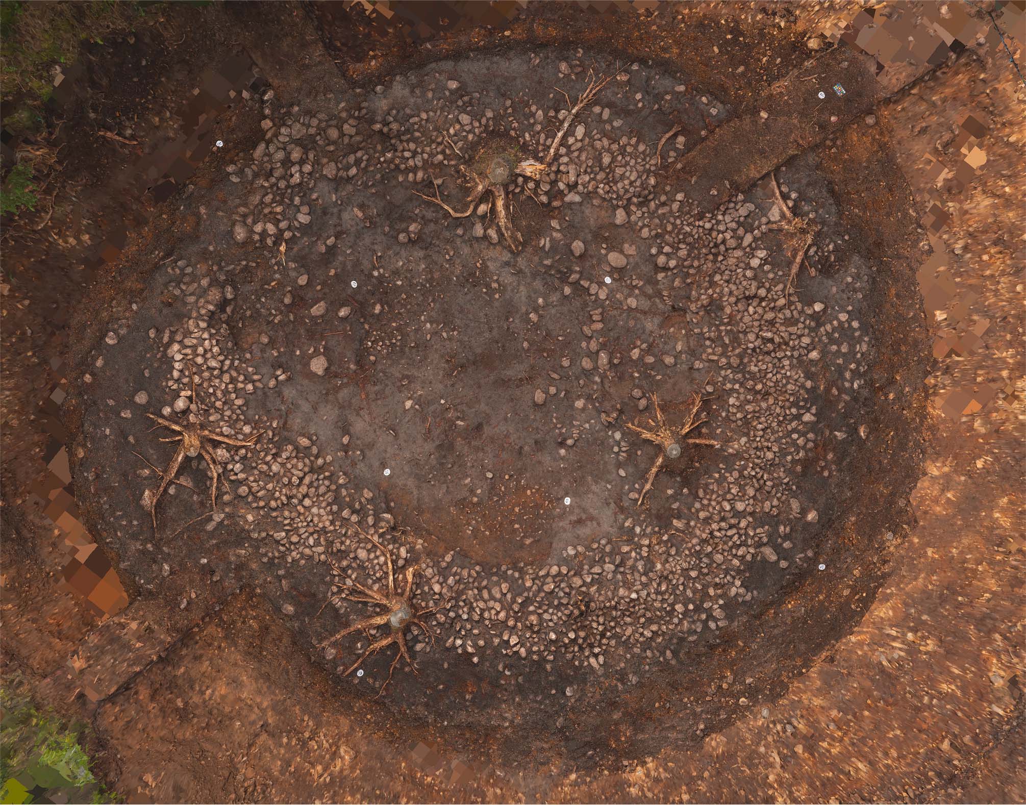
A Middle Bronze Age Roundhouse at Beauly Substation, Beauly, Inverness-shire
Vol. 115 (2026)A Middle Bronze Age Roundhouse at Beauly Substation, Beauly, Inverness-shire
Authors: Callum Murray
Contributors: Aurimė Bočkutė, Genoveva Dimova, Rob Engl, Orlene McIlfatrick, Dawn McLaren, Jackaline Robertson and Lynne Roy
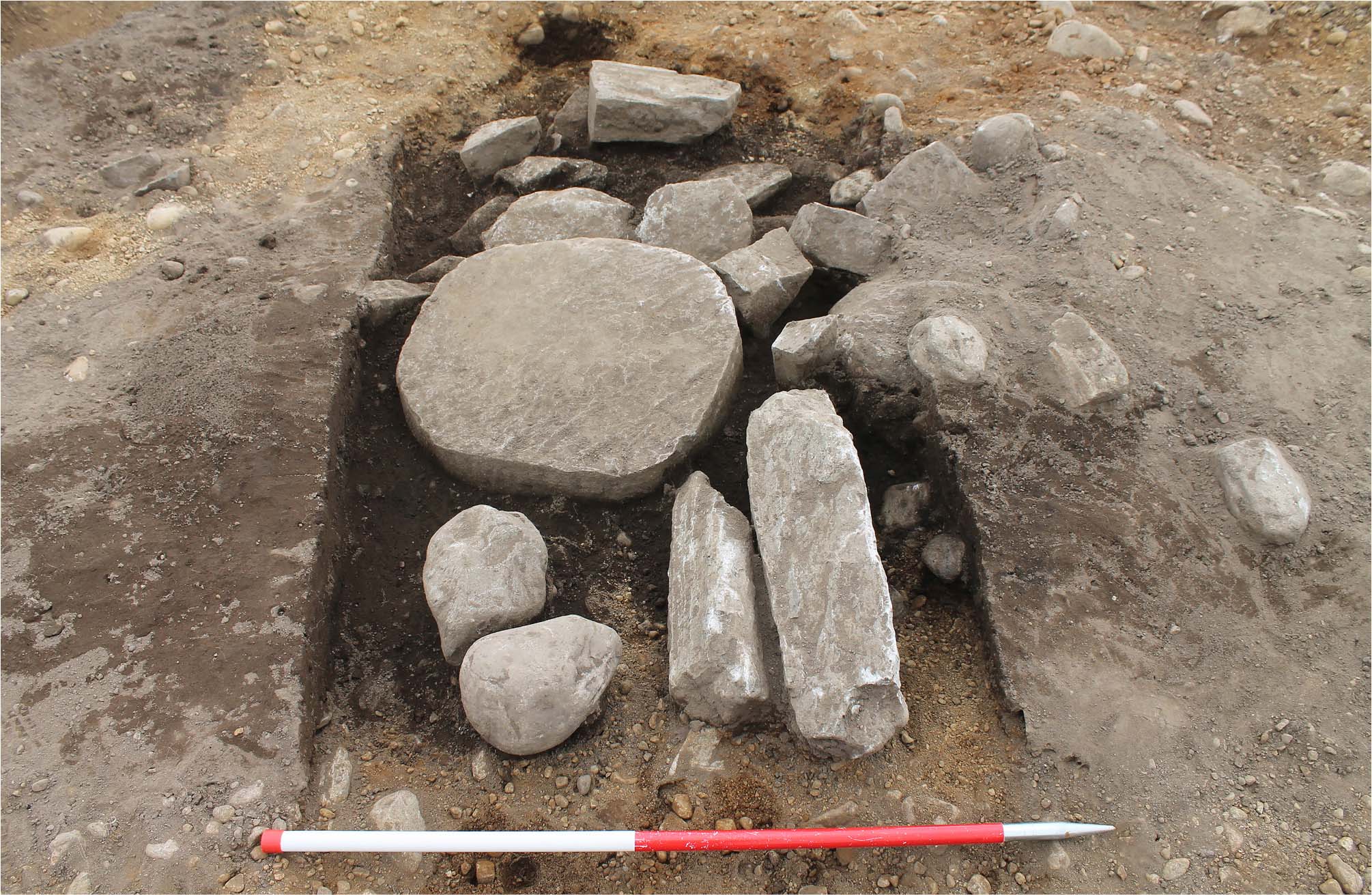
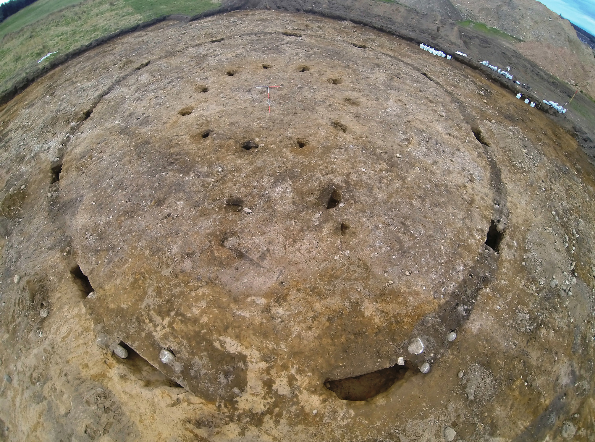
Illustrations by Mark Hoyle, Sam O’Leary and Lindsey StirlingSummary: AOC Archaeology Group undertook archaeological mitigation fieldwork in advance of substation reinforcement works at Beauly Substation, Beauly, Inverness-shire, Highland (centred on NGR: NH 5036 4455). Excavation identified the remains of a roundhouse of Middle Bronze Age date, comprising a turf and stone bank and an internal post setting. A small assemblage of macroplant and charcoal was recovered from the site, as well as two saddle querns, two flint artefacts, and sherds of prehistoric pottery. The site lies within a complex prehistoric landscape that has undergone intensive modern archaeological investigation. Combined with the present works, this has revealed a landscape consisting of domestic and agricultural elements comprising roundhouses and associated field systems, as well as funerary elements such as cists and burial cairns. Beauly provides an informative landscape case study, which can be compared with similar sites in the Scottish Highlands such as Navidale, Lairg, and Dalchork.
Keywords: Middle Bronze Age, roundhouse, field system
Location: Beauly Substation, Beauly, Inverness-shire, Highland NGR: NH 5036 4455
Periods: Chalcolithic/Bronze Age
NRHE ID: 376515

This work is licensed under a Creative Commons Attribution-NonCommercial 4.0 International Licence.
-
A Later Prehistoric Settlement and Early Medieval Reuse at Loak Farm, Bankfoot, Perth and Kinross
Vol. 114 (2026)A Later Prehistoric Settlement and Early Medieval Reuse at Loak Farm, Bankfoot, Perth and Kinross
Authors: Magnus Kirby
Contributors: Diane Alldritt, Hannah Britton, Ann Clarke, Melanie Johnson and Rod Mackenzie
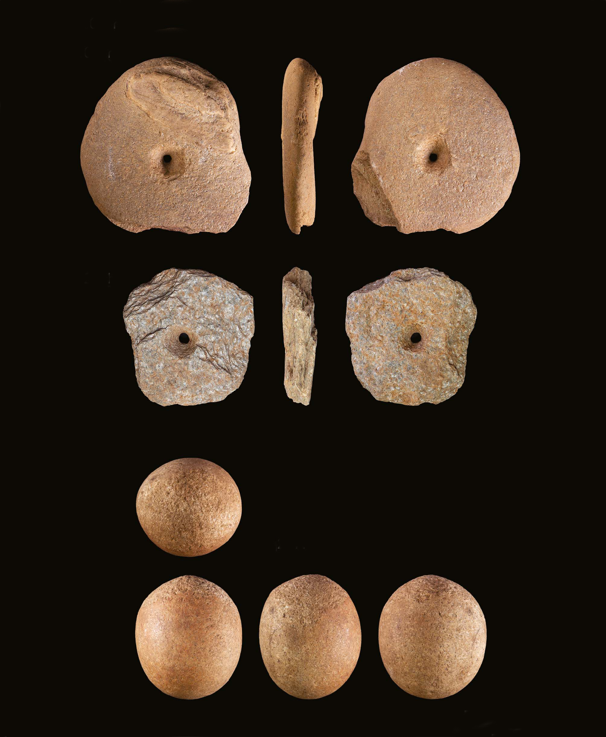
Illustrations by Alan Braby, Rachael Kershaw, Sam Griffith and Woody MusgroveSummary: An open area excavation was undertaken at Loak Farm, Bankfoot, Perth and Kinross in 2019 in advance of a borrow pit being opened to supply stone for work on the A9 dualling project. The excavation uncovered seven roundhouses, eight four-post structures, two six-post structures, two ring ditches, an oval post-built structure, a lightweight post-built structure, a post- and post-trench structure, and numerous isolated pits and groups of pits. Radiocarbon dating places the majority of these features in the Late Bronze Age and Iron Age, indicating that the site was a fairly extensive settlement of later prehistoric date. A small assemblage of pottery and coarse stone tools was recovered; the stone tools indicated some limited craftworking activities were taking place at the site. Several features, including a corn-drying kiln and possible field oven, and pits containing ironsmithing evidence, returned dates in the very early medieval period, indicating some reuse of the settlement into the second half of the first millennium AD.
Keywords: Late Bronze Age, Iron Age, medieval, roundhouse, four-post structure, ring-ditch, rural settlement, kiln
Location: Loak Farm, Bankfoot, Perth and Kinross, NO 07400 33200
Periods: Neolithic, Bronze Age, Roman & Iron Age, Medieval
NRHE ID: 370116
This work is licensed under a Creative Commons Attribution-NonCommercial 4.0 International Licence.
-
A Middle Bronze Age settlement near Mauchline, East Ayrshire
Vol. 113 (2026)A Middle Bronze Age settlement near Mauchline, East Ayrshire
Authors: Stephen Cox and Fraser McFarlane
Contributors: Laura Bailey, Beverley Ballin Smith FSAScot, Michael Bamforth, Julie Franklin FSAScot, Julie Lochrie and Fiona McGibbon
Summary: The excavation of a parcel of land north of Mauchline, East Ayrshire, in advance of a housing development uncovered evidence of human activity from the Neolithic to the post-medieval period. The Neolithic period was represented by a well-preserved assemblage of charred hazelnuts and crab apples in a pit. During the later prehistoric period, the main focus of activity comprised a roundhouse and a souterrain within a fenced enclosure. Radiocarbon dates obtained from the roundhouse and the souterrain indicated a Middle Bronze Age date for these features, strongly suggesting that souterrains existed in this part of Scotland much earlier than previously thought.
Keywords: Souterrains, Middle Bronze Age, Ayrshire, radiocarbon dating, enclosure, Neolithic
Location: Isle of Arran, NR 9149 2685
Periods: Neolithic, Bronze Age
NRHE ID: 365701
This work is licensed under a Creative Commons Attribution-NonCommercial 4.0 International Licence.
-
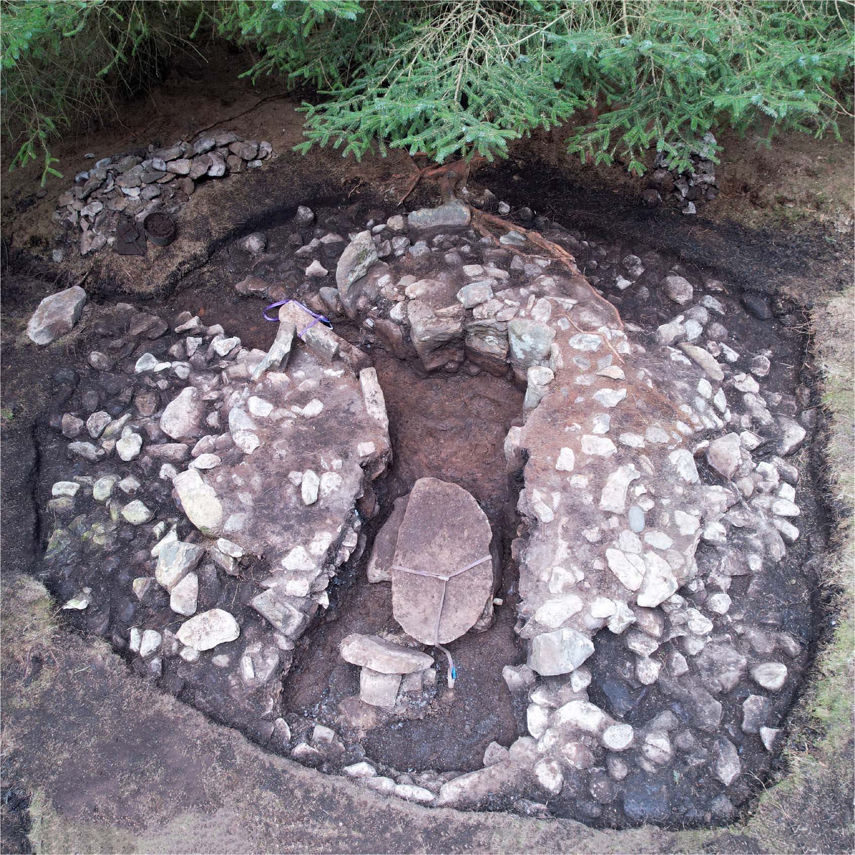
The re-examination of the Carmahome passage tomb, Isle of Arran, North Ayrshire
Vol. 112 (2025)The re-examination of the Carmahome passage tomb, Isle of Arran
Authors: Clare Ellis, Matt Ritchie and Alison Sheridan
Contributors: Sue Anderson, Derek Hamilton and Susan Ramsay
Summary: The unusual simple passage tomb of Carmahome was partially excavated over the course of two days in 1924 by the landowner James Craig and archaeologist Ludovic McLellan Mann. This excavation revealed a small round cairn with a central chamber formed by a circular setting of ten upright stones and a short, narrow passage that led into the central chamber from the west. The monument had been cleared out, with just a single artefact (a flint knife) recovered from under one of the floor slabs. Almost 100 years later, in 2022, Carmahome was re-examined, with the primary aim being to search for organic material that could be used to radiocarbon date the construction of the monument and contribute to our understanding of this type of site. A total of seven samples were recovered and processed for radiocarbon dating by accelerator mass spectrometry (AMS). A Bayesian approach was then applied to the interpretation of the chronology of the archaeological activity at Carmahome, and the results appear to suggest that the monument was constructed during the Late Neolithic, around 3055–2890 cal BC, and was perhaps only used over the course of a few generations before being abandoned; the monument, then in a state of disrepair, was re-used in the Chalcolithic period, with a Beaker being deposited within. However, a second hypothesis is also offered, suggesting the cairn was constructed in the Early Neolithic, as a passage tomb with a low kerbed cairn, and then saw reuse in the Late Neolithic and Chalcolithic periods.
Keywords: Neolithic; chambered cairn; simple passage tomb; antiquarian excavation; excavation
Location: Isle of Arran, NR 9149 2685
Periods: Neolithic
Canmore ID: 39628
This work is licensed under a Creative Commons Attribution-NonCommercial 4.0 International Licence.
-
A multi-period settlement next to the River Spey, Craggan, Grantown-on-Spey
Vol. 111 (2025)A multi-period settlement next to the River Spey, Craggan, Grantown-on-Spey
Authors: Leonie Teufel
Contributors: Daniel Bateman, Rob Engl, Amy Halliday, Dawn McLaren, Andrew Morrison, Jackaline Robertson, Michael Roy and Mara Tesorieri
Summary: Archaeological works undertaken in 2019 and 2020 in advance of development of the Cairn Distillery, Grantown-on-Spey identified remains of a multi-period landscape spanning the Late Mesolithic to the medieval period. The earliest phase of activity on site was evidenced by residual material from the Mesolithic-Neolithic transition. A Late Neolithic cremation pit was also identified, comprising the cremated remains of at least one adult male. Following this funerary activity, the remains of a Late Bronze Age fire pit were identified. Additionally, at least three post-defined Middle Iron Age roundhouses and metalworking features were recorded. Late Iron Age and early medieval settlement and industrial activity was evidenced by the remains of at least three roundhouses, with fire and refuse pits, a four-post granary, a metalworking furnace, and metal waste pits. The artefact assemblage included worked and coarse stone, as well as metal finds. Notable stone finds included a Late Mesolithic chipped stone, several Late Iron Age rotary quernstones and a large millstone roughout, while Middle Iron Age and early medieval slag and metalworking waste were indicative of small-scale smelting at the site. The finds at Craggan represent a significant site along the River Spey, comprising multiple phases of settlement, funerary activity, and craftworking from the Mesolithic to the medieval period.
Keywords: Roundhouse settlement; Iron Age; Early medieval; Multi-period
Location: Craggan, Grantown-on-Spey, NGR: NJ 01865 25612
Periods: Mesolithic, Neolithic, Chalcolithic/Bronze Age, Iron Age, Medieval
This work is licensed under a Creative Commons Attribution-NonCommercial 4.0 International Licence.
-
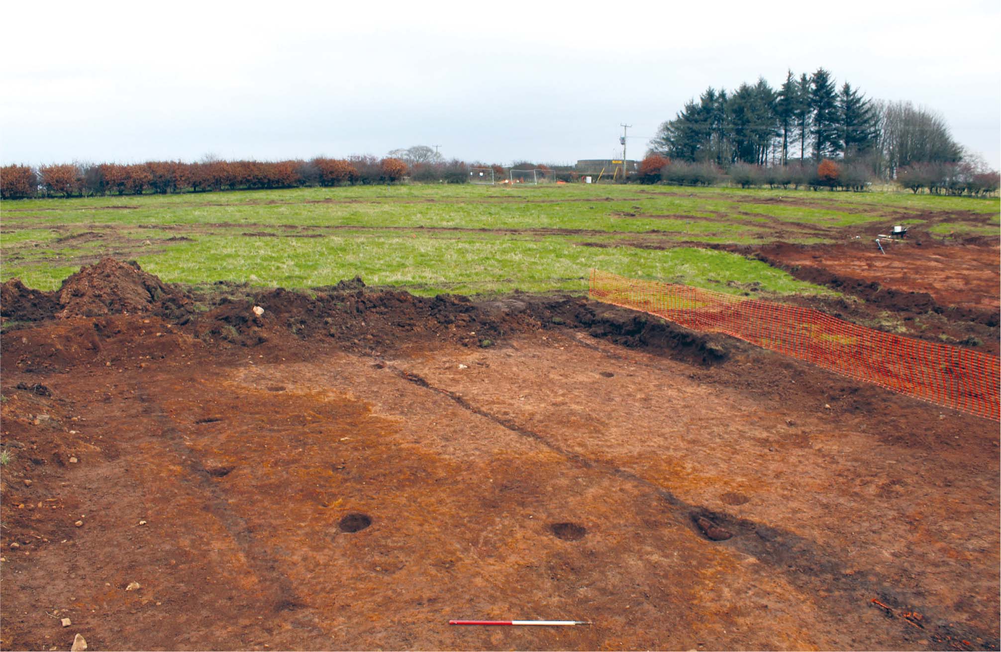
Prehistoric and Medieval Activity at Grantown Road, Forres, Morayshire
Vol. 110 (2025)Prehistoric and Medieval Activity at Grantown Road, Forres, Morayshire
Authors: Lindsay Dunbar
Contributors: Julie Dunne, Richard Evershed, Rob Engl, Toby Gillard, George Haggarty, Simon Howard, Dawn McLaren, Ann MacSween, Andrew Morrison, Jackaline Robertson and Mike Roy
Summary: Archaeological excavations conducted in 2017 at Grantown Road, Forres form the final phase of works on a residential development that began in 2002. The earlier works examined an area of more than 70ha and confirmed the presence of an extensive Iron Age settlement represented by ring-ditch, ring-groove, and post-ring structures, in association with four-post structures, a souterrain, and metalworking furnaces. The 2017 works (Canmore ID 320363), reported here, have expanded the record of prehistoric and medieval settlement in the area and revealed that a previously recorded cropmark site represented an Iron Age enclosure with a single post-ring roundhouse. Also identified in the present works were an Early Neolithic post-ring structure and a series of pits dating from the Neolithic to the medieval periods with artefact assemblages of pottery, lithics, and stone tools, including a rare fragment of a locally made mortar dated to the 13th century ad.
Keywords: Neolithic, Iron Age, medieval, enclosure, post-ring, roundhouses, mortar
Location: Grantown Road, Forres, Morayshire, (NJ 03255730), Scotland, UK
Periods: Mesolithic, Neolithic, Chalcolithic/Bronze Age, Iron Age, Medieval
Canmore ID: 320363
This work is licensed under a Creative Commons Attribution-NonCommercial 4.0 International Licence.
-
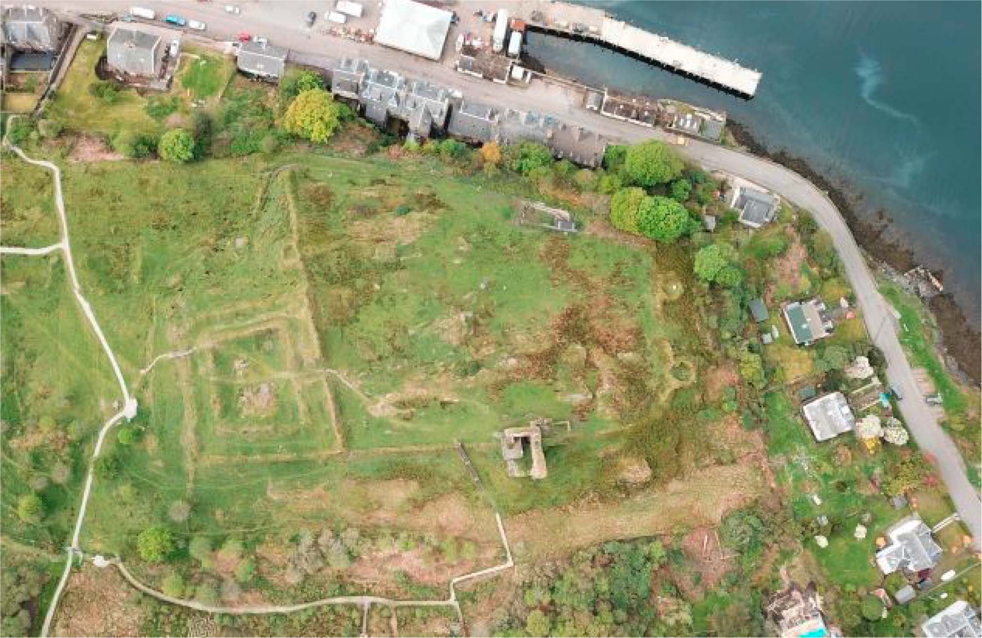
Tarbert Castle, Argyll: Community Excavations at a Royal Castle of Robert I
Vol. 109 (2025)Tarbert Castle, Argyll: Community Excavations at a Royal Castle of Robert I
Authors: Roddy Regan
Contributors: Derek Hall, Andrew Morrison, Genoveva Dimova, Helen Newton & Ingrid Mainland and Dawn McLaren
Summary: An early historic C7th-C8th date recovered from a deposit sealed below the castle walls raises the intriguing possibility of the site being the ‘Tairpirt Boittir’ mentioned in the Irish annals. The excavation work demonstrated that both the Inner Bailey and Outer Bailey of Tarbert Castle were likely constructed at the same time and not the result of two separate building campaigns as previously thought. The well-preserved medieval deposits that survive across the site, suggest the castle was occupied from the earlier 14th century and the excavated evidence indicates the construction of the castle is likely the work of Robert I. The excavation work has also revealed several important aspects of the construction and layout of the castle confirming the presence of two portcullis gates giving access into the Outer Bailey while shedding light on the corner tower at the southwest of the same enclosure. The excavation also located the remains of one medieval building along with medieval deposits lying on the ridge south of the main castle, these likely confirming the presence of the medieval burgh previously postulated as being located in this area.
Keywords: Castle, Burgh, Tarbert, Knapdale, Argyll, Medieval, Robert I, Excavation
Location: Tarbert (NR 86770 68730), Scotland, UK
Periods: Medieval
Canmore ID: Tarbert Castle 39316; Tarbert Medieval Burgh 39321
This work is licensed under a Creative Commons Attribution-NonCommercial 4.0 International Licence.
-
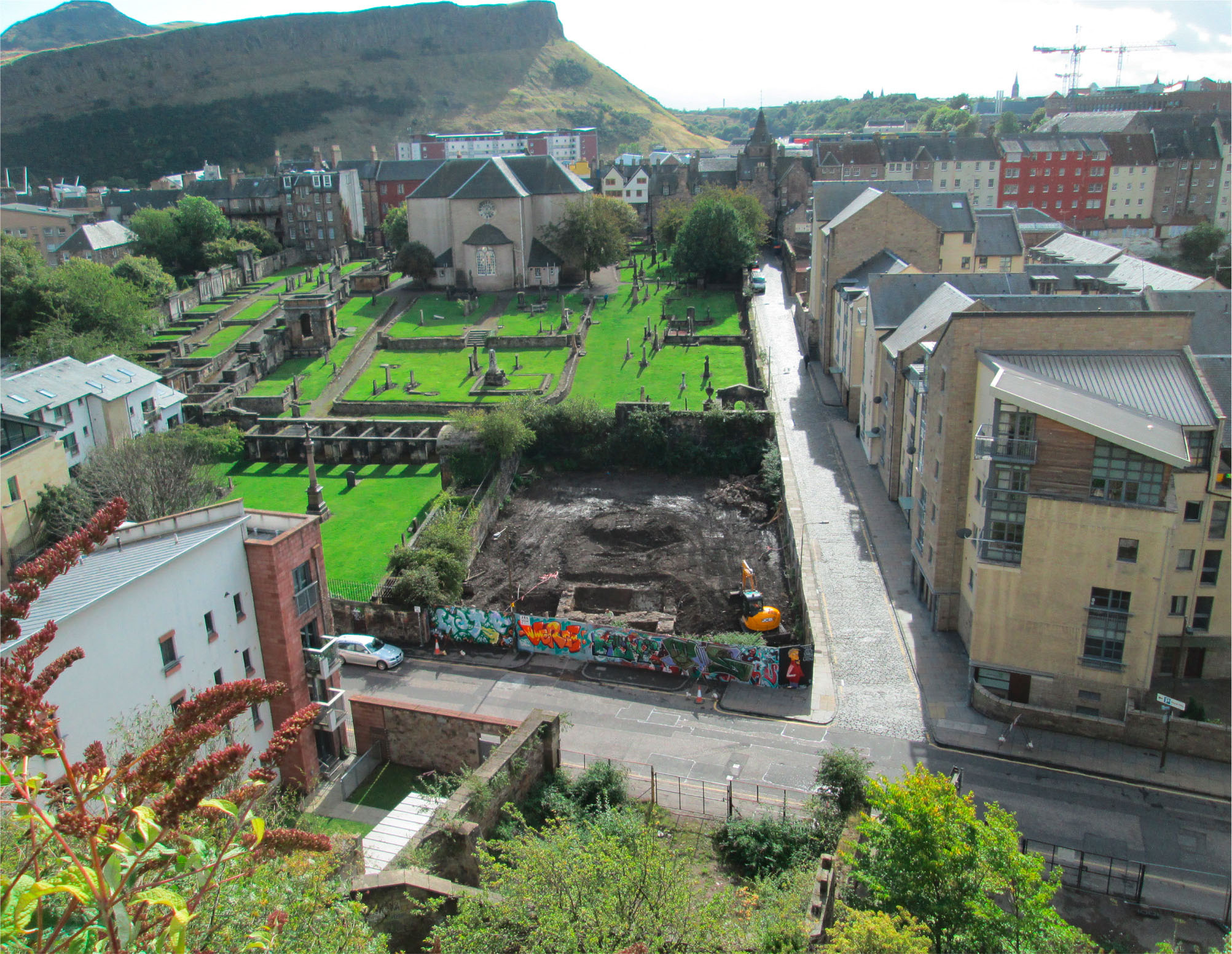
Rich Man, Poor Man: Excavations at the Canongate Poorhouse, New Waverley, Calton Road, Edinburgh
Vol. 108 (2025)Rich Man, Poor Man: Excavations at the Canongate Poorhouse, New Waverley, Calton Road, Edinburgh
Authors: Rob Engl and Martin Cook
Contributors: Thomas Bradley-Lovekin, Anne Crone, Dennis Gallagher, George Haggarty, Derek Hall, Rachel Ives, Alexandra Johnson, Dawn McLaren, Jackaline Robertson, Hugh Willmott and Penelope Walton-Rogers
Summary: In 2013 excavation works were undertaken at the location of the former Canongate Charity Poorhouse (or workhouse) on the New Waverley development site, at the junction of Calton Road and Old Tolbooth Wynd, Canongate, Edinburgh. The excavation revealed development of the site from the initial cultivation of the ‘backlands’ in the 12th/13th centuries to the construction of the Poorhouse in 1761.
A sequence of buried garden soils/middens relating to pre-18th-century activity was recorded, in addition to the remains of a single burgage plot boundary and associated rig and furrow deposits. Substantial structural features related to the 18th-century Poorhouse were revealed, including sandstone walls with wooden plank and pinion foundation rafting. Seven burials of probable late 17th-/early 18th-century date associated with the Canongate Kirk were recorded along the site’s southern boundary (an eighth had been encountered in 1997).
A rich artefact and ecofact assemblage was recovered from the soils and midden deposits, including imported fine glassware. The ceramic assemblage included Scottish White Gritty Ware (SWGW), Scottish Post-medieval Reduced Ware (SPMRW) and Scottish Post-medieval Oxidised Ware (SPMOW), together with high-status imported material such as a Spanish gaming piece and a rare German stove tile.
Consumption patterns revealed by the artefact evidence appear to reflect the high status of the Canongate’s inhabitants prior to the greater development of the site during the 18th century. The creation of the Poorhouse stands in stark contrast to this, revealing the changing fortunes of this part of post-medieval Edinburgh.
Keywords: Canongate, poorhouse, cemetery, Caltongate
Location: Edinburgh , Scotland, UK
Periods: Medieval, Post Medieval, Modern
Canmore ID: 160786
This work is licensed under a Creative Commons Attribution-NonCommercial 4.0 International Licence.
-
Jedburgh Abbey Rampart: The Treatment of the Dead
Vol. 107 (2024)Jedburgh Abbey Rampart: The Treatment of the Dead
Authors: Ian Hill and Michelle Gamble
Contributors: Derek Hall, Mary Márkus, Alice Blackwell, Jennifer Thoms, Thomas Booth, Kyriaki Anastasiadou, Alexandre Gilardet, Marina Soares Da Silva, Monica Kelly, Mia Williams, Pooja Swali and Pontus Skoglund
Summary: An archaeological watching brief was undertaken at the Jedburgh Abbey Rampart during repair and construction works to consolidate and secure the ‘rampart’ wall and its face, both of which had begun to deteriorate and fail. The watching brief followed on from earlier works to investigate the construction of the ‘rampart’, which had revealed the presence of disarticulated skeletal remains behind the wall. The excavations undertaken during the repair works have helped to infer the methods employed for the construction of the ‘rampart’, likely dating to the late 18th century. During construction several burials of the former Low Kirkyard were disturbed and displaced, with the disarticulated remains of several skeletons found within the construction deposits. The watching brief also revealed the remains of five burials that were partially disturbed during construction, with skeletal remains dating from the 15th century onwards. Disturbance to earlier graves, not disturbed by the construction, were also identified, the results of which indicate changing attitudes to skeletal remains through the post medieval and early modern periods.
Keywords: Late medieval, post medieval, burial practices, Abbey, Scottish Borders
Location: Jedburgh, Scottish Borders, Scotland, UK
Periods: Late Medieval, Post Medieval, Early Modern

This work is licensed under a Creative Commons Attribution-NonCommercial 4.0 International Licence.
-
Cowhides and motorcars: the history of Beaverbank Tannery
Vol. 106 (2024)Cowhides and motorcars: the history of Beaverbank Tannery
Authors: Morag Cross, Magnar Dalland and Debora Moretti
Summary: The proposed development at Beaverbank Place, Canonmills, Edinburgh led to the excavation of the remains of the 19th-century Beaverbank Tannery. Accompanying historical research allowed the history of the ownership and tenancies of the buildings and various businesses to be traced from 1807 to 1959. This included the early 19th-century Clark’s Mill linen bleachers and the 1868 tannery built by the Johnston family and later leased by family firms of the Pringles and Walkers. A period of abandonment between 1913 and 1915 was followed by the repurposing of the building as a sawmill and cooperage. Part of the site changed again to become a motor garage in 1928.
The remains can be matched well with historic map evidence and appear to relate predominantly to the late 19th-century tannery structures. Remains were found of approximately 100 tanning pits set out in a grid pattern, with further features related to drainage, paving and other structures. Very little environmental or artefactual evidence was recovered to shed light on specific practices, materials used or materials produced.
There were also scant structural remains that could be related to the earlier linen bleachers and to the later motor garage.
Keywords: tannery, industrial history, social history, Edinburgh
Location: Beaverbank Place, Edinburgh, Scotland, UK
Periods: Modern
This work is licensed under a Creative Commons Attribution-NonCommercial 4.0 International Licence.

