
Archives - Page 11
-
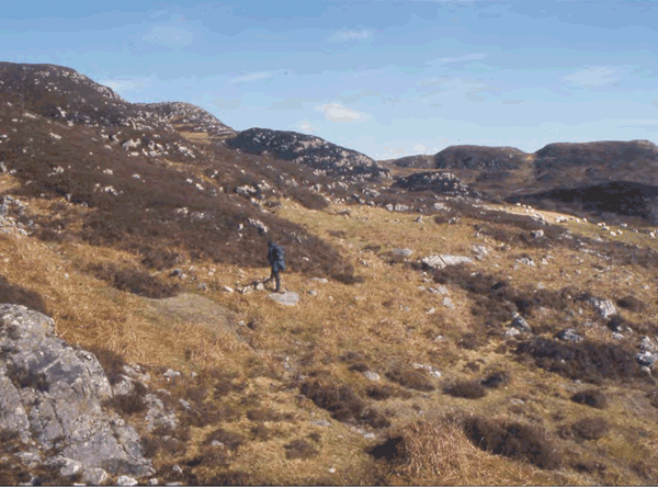
Early land-use and landscape development in Arisaig
Vol. 15 (2005)Early land-use and landscape development in Arisaig
Contributor: Caroline Wickham-Jones
Summary: Re-alignment of a 6km section of the A830 road in Arisaig (NGR: NM 6714 9054) provided an opportunity to investigate the archaeology of this poorly understood area of the West Highlands. A combination of archaeological and palaeoenvironmental techniques were used to investigate the road corridor. Archaeological survey, followed up by selected excavations, identified a previously unrecorded Bronze Age kerb cairn and two areas of shieling huts. Investigation of the shielings obtained evidence for repeated reuse of sites and reconstruction of structures through the medieval and post-medieval periods. In both cases, Bronze Age deposits were also recorded at the base of the medieval sequence. Analysis of a long peat core from a basin close to one of the shielings revealed a history of continuous but gradual decline in woodland, starting in about 3200 BC and continuing to the present day. Collation of archaeological and palaeoenvironmental data from the present project and previous investigations in the area have allowed the creation of a tentative model of landscape evolution for Arisaig.
Keywords: Basin, Kerb Cairn, Palaeoenvironmental Data
Periods: Medieval, Bronze Age
Location: Highland, Scotland, UK
-
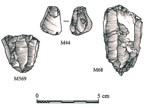
People and their monuments in the Upper Clyde Valley: a programme of survey, field walking and trial excavation in the environs of the Blackshouse Burn Neolithic enclosure, South Lanarkshire, 1989–99
Vol. 14 (2005)People and their monuments in the Upper Clyde Valley: a programme of survey, field walking and trial excavation in the environs of the Blackshouse Burn Neolithic enclosure, South Lanarkshire, 1989–99
Contributors: Torben Bjarke Ballin, Caitlin Evans and John Arthur
Summary: This report sets out the results of a programme of topographic survey, geophysical survey, field walking and trial excavation, carried out in 1998–99 and funded by Historic Scotland, in and around an extensive upland prehistoric landscape in the Upper Clyde Valley. It was designed to build on the results of limited excavation of a large, late Neolithic enclosure at Blackshouse Burn, South Lanarkshire (NGR: NS 9528 4046) and preliminary survey of nearby monuments undertaken in the 1980s, and to identify and characterize prehistoric settlement in the adjacent valleys through field walking. Topographic survey of the enclosures at Blackshouse Burn, Meadowflatts and Chester Hill, and of hut circles, clearance cairns and a possible ring cairn on Cairngryffe and Swaites Hills, recorded a complex ritual and domestic landscape: evidence of the longstanding prehistoric occupation of the Pettinain Uplands. The geophysical survey of Chester Hill enclosure found traces of internal structures and quarry scoop, while geophysical survey of part of the large Blackshouse Burn monument and smaller adjacent enclosure found evidence for a curvilinear feature in the large enclosure and a possible screen in its entrance. The systematic examination of ploughed fields in the valleys to the west and south-west of the upland monument complex discovered several concentrations of lithics, most notably evidence of late Mesolithic tool production and late Neolithic to early Bronze Age tool production and domestic activity. Trial trenches excavated over a late Mesolithic cluster at Carmichael found a knapping floor and several structural features.
Keywords: Floor, Enclosures, Geophysical Survey, Cairns, Enclosure, Ritual, Settlement, Topographic Survey , Geophysical Survey
Periods: Mesolithic, Neolithic, Bronze Age, Prehistoric
Location: South Lanarkshire, Scotland, UK
-
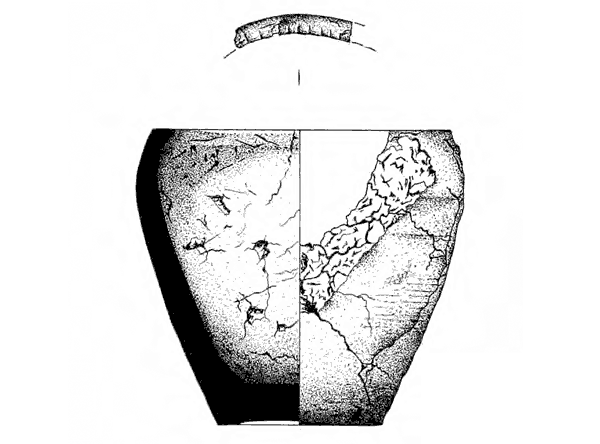
Excavation of a Bronze Age kerbed cairn at Olcote, Breasclete, near Calanais, Isle of Lewis
Vol. 13 (2005)Excavation of a Bronze Age kerbed cairn at Olcote, Breasclete, near Calanais, Isle of Lewis
Contributors: Kathleen McSweeney, Stephen Carter, Melanie Johnson, Graeme Warren, Paula Milburn, Michael Church
Summary: An archaeological excavation was carried out by the Centre for Field Archaeology (CFA) from October to December 1995 of a Bronze Age kerbed cairn at Olcote, Breasclete, Isle of Lewis (NGR: NB 2180 3475). The cairn was discovered by CFA during an evaluation of a dense scatter of worked and unworked quartz made by local archaeologists, Margaret and Ron Curtis. The remains lay in the path of the improvement of the single track road through Breasclete. A range of archaeological features and deposits was identified and recorded within the excavation trench. These fell into three groups on stratigraphic grounds: pre-cairn features, including pits, spade or cultivation marks and a buried ground surface; the cairn itself, including inner and outer kerbs, burnt peat deposits, a central cist and other features; and modern deposits which cut the cairn, including post-holes and field drains. Excavation and post-excavation were wholly funded by Historic Scotland.
Keywords: Postholes, Kerbed Cairn, Pits Spade, Cultivation Marks, Worked, Excavation, Central Cist
Periods: Bronze Age, Mesolithic
Location: Western Isles, Scotland, UK
-
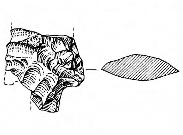
Camas Daraich: a Mesolithic site at the Point of Sleat, Skye
Vol. 12 (2004)Camas Daraich: a Mesolithic site at the Point of Sleat, Skye
Contributors: Ann Clarke, Michael Cressey, Kevin Edwards and Anthony Newton
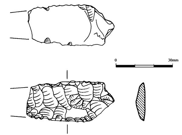
Summary: The archaeological site of Camas Daraich on the peninsula of the Point of Sleat, in south-west Skye (NGR: NG 567 000) was revealed in November 1999 when stone tools were discovered in the upcast from a newly bulldozed track. Excavation took place in May 2000, directed by the authors and under the auspices of Historic Scotland, the Centre for Field Archaeology and the Department of Archaeology, University of Edinburgh. The excavations were small-scale and brief, but they demonstrated the survival of stratified features, including scoops and a possible hearth, as well as an assemblage of nearly 5000 flaked lithics, comprising both tools and debris. There was no organic preservation, with the exception of burnt hazelnut shell. The composition of the lithic assemblage suggested that the excavated site was Mesolithic and this was confirmed by the radiocarbon determinations, which place it securely in the mid-7th millennium BC. Surface material suggested that there was evidence for more recent prehistoric stone-tool-using activity in the vicinity.
Keywords: Stone Tools, Burnt Hazelnut Shell, Hearth, Settlement, Flaked Lithics, Debris
Periods: Mesolithic, Prehistoric
Location: Highland, Scotland, UK
-
The worked quartz vein at Cnoc Dubh, Uig parish, Isle of Lewis, Western Isles: presentation and discussion of a small prehistoric quarry
Vol. 11 (2004)The worked quartz vein at Cnoc Dubh, Uig parish, Isle of Lewis, Western Isles: presentation and discussion of a small prehistoric quarry
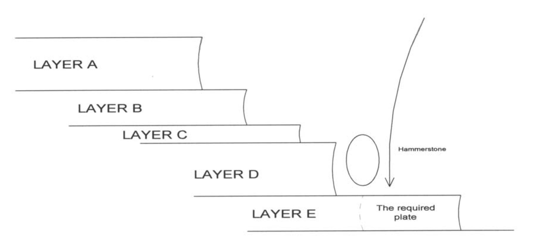
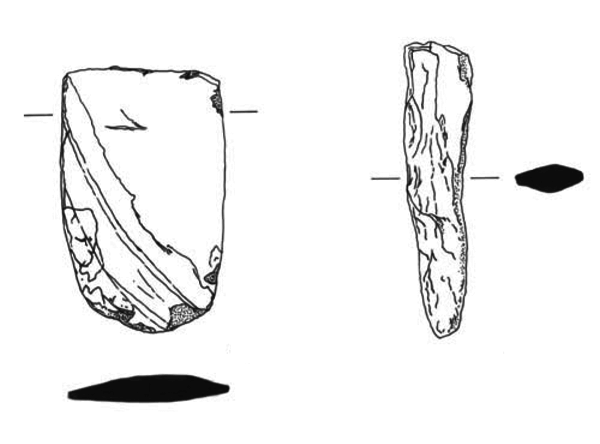
Summary: In 2002, an examination was carried out of a small quartz vein at the knoll of Cnoc Dubh, a few hundred metres from the southern shores of Loch Ceann Hulabhig on the Isle of Lewis (NGR: NB 2318 2998). The vein proved to have been worked in prehistoric time, defining it as a quarry, and it was measured, photographed and characterized. In the present paper, the Cnoc Dubh quartz quarry is presented in detail, to allow comparison with other lithic quarries, and it is attempted to define attributes diagnostic of prehistoric exploitation, and to schematically describe the 'mining operations' by which the quartz was procured. As part of this process,quartz quarrying is compared to the procurement of other lithic and stone raw materials, mainly drawing on research from Scandinavia, Australia and the USA, and the location of quartz quarries in relation to prehistoric settlements is discussed. The average distance between quartz sources and Neolithic–Bronze Age sites on Lewis is then used to discuss ownership of, and access to, prehistoric quartz sources, as well as the possible exchange of quartz.
Keywords: Lithics, Pottery, Quarry
Periods: Prehistoric, Iron Age, Bronze Age, Neolithic
Location: Western Isles, Scotland, UK
-
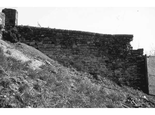
Conservation and change on Edinburgh's defences: archaeological investigation and building recording of the Flodden Wall, Grassmarket 1998–2001
Vol. 10 (2003)Conservation and change on Edinburgh's defences: archaeological investigation and building recording of the Flodden Wall, Grassmarket 1998–2001
Contributors: Colin Wallace, Jonathan Millar, Mike Middleton
Summary: This report presents the results of a historic building survey and archaeological watching brief undertaken between 1998 and 2001 during restoration work, as part of the Scottish Dance Base development, on the Flodden Wall running between Edinburgh's Grassmarket and Johnston Terrace (NGR: NT 252 733). The Flodden Wall is the name given to the 16th-century extension of the capital's town defences, traditionally seen as having been constructed in the months following the defeat at Flodden in 1513. Prior to this project the extent and condition of this particular stretch of the Flodden Wall (the north-western boundary of the Grassmarket and a Scheduled Ancient Monument) was not fully understood. This project has shown that here the Flodden Wall and surrounding area had undergone three major phases of construction and redevelopment, from its origins in the early 16th century to the formation of a drying green (Granny's Green) to the west of the Wall in the late 19th century. In particular the results have demonstrated that the surviving southern section of the Wall here was largely rebuilt during the third quarter of the 18th century, when a complex of buildings was constructed along Kings Stables Road abutting the Wall's western face.
Keywords: Boundary, Building Survey, Defences, Ancient Monument, Flodden Wall, Scottish Dance Base
Periods: Medieval, 16th century
Location: Edinburgh, Scotland, UK
-
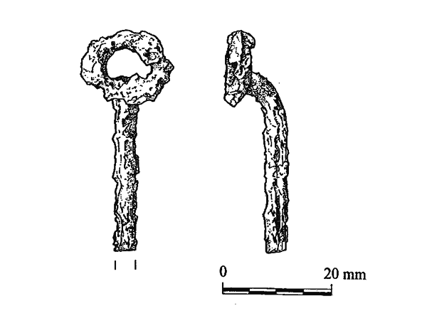
Excavation of an Iron Age burial mound, Loch Borralie, Durness, Sutherland
Vol. 9 (2003)Excavation of an Iron Age burial mound, Loch Borralie, Durness, Sutherland
Contributors: Julie Roberts, Adrian Cox, Michael Donnelly, Caitlin Evans, John Arthur
Summary: As part of the Historic Scotland Human Remains Call Off Contract, Glasgow University Archaeological Research Division (GUARD) undertook an archaeological evaluation of the find spot of a human skull from a cairn at Loch Borralie, Sutherland (NGR: NC 3790 6761). Excavation recovered the remains of two burials beneath the cairn and established that the cairn was multi-phased. One individual was an adult male (Skeleton 1), while the other was immature and of undeterminable sex (Skeleton 2). Both individuals showed signs of ill health, and dogs and/or rats appear to have gnawed their bones. A ring-headed pin was recovered close to Skeleton 1 during the excavation. A radiocarbon date was obtained from the left humerus of Skeleton 1 of 40 cal BC - cal AD210 at 2 sigma (OxA-10253). Excavation revealed that the cairn, broadly sub-rectangular in form, had a maximum height of 1.2m and was composed of large, sub-angular and sub-rounded rocks (including quartz and quartzite) and occasional rounded cobbles within yellow-orange sand. One inhumation, Skeleton 2, lay within an irregular grave, cut through the red brown sand that was sealed by the cairn and into the natural gravel sand below. The other inhumation, Skeleton 1, was sealed by the red brown sand and had been placed on a low primary cairn of stone and earth, the full extent and depth of which remains unknown. The tradition of extended inhumations within sub-rectangular cairns is a recognised funerary practice in the north of Britain during the first millennium AD. Many of these burials are generally considered to be Pictish in date, but Loch Borralie indicates that the tradition commenced in the Iron Age. There is increasing evidence for the variety of ways in which human remains were treated after death in the Iron Age, including cremations in re-used cists, single inhumations in graves and cists, multiple inhumations and the incorporation of human remains in 'domestic' contexts. The results of the excavation of the burial mound at Loch Borralie provide a useful addition to the range of mortuary and funerary rites which were practised during the Iron Age in Scotland.
Keywords: Pin, Cremations, Human Remains, Graves, Burial Mound, Inhumation, Mortuary, Excavation, Cairn, Funerary, Human Skull, Stone, Burials
Period: Iron Age
Location: Highland, Scotland, UK
-
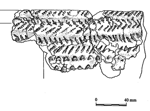
Excavation of an urned cremation burial of the Bronze Age, Glennan, Argyll and Bute
Vol. 8 (2003)Excavation of an urned cremation burial of the Bronze Age, Glennan, Argyll and Bute
Contributors: Jennifer Miller, Julie Roberts, Michael Donnelly, Gary Tompsett, Caitlin Evans
Summary: As part of the Historic Scotland Human Remains Call Off Contract, Glasgow University Archaeological Research Division (GUARD) undertook an archaeological excavation of a prehistoric urned cremation deposit within a boulder shelter at Glennan, Kilmartin, Argyll and Bute (NGR: NM 8622 0097). Analysis has shown the cremation was of a male probably aged between 25 and 40 years. He had suffered from slight spinal joint disease, and mild iron deficiency anaemia, though neither seems likely to have affected his general health. He was cremated shortly after death, together with a young sheep or goat, and their remains were subsequently picked from the pyre and co-mingled before burial in the urn. An unburnt retouched flint flake was recovered which may have accompanied the burial. The closest parallels for the cremation container are found within the tradition of Enlarged Food Vessel urns, a tradition that is poorly dated but probably has a currency in the first half of the second millennium BC.
Keywords: Inhumation, Funerary Practices, Cremation Burials, Animal Bone, Charcoal, Mortuary, Glennan Urn, Ceremonial, Bone, Cremation, Boulder Shelter, Urn, Flint Flake
Periods: Bronze Age, Neolithic, Prehistoric
Location: Argyll and Bute, Scotland, UK
-
Catpund: a prehistoric house in Shetland
Vol. 7 (2005)Catpund: a prehistoric house in Shetland
Contributors: Torben Ballin, Camilla Dickson, Stephen Carter, Paul Sharman, John Arthur
Summary: A prehistoric house was excavated in advance of industrial quarrying at Catpund, Shetland (NGR: HU 4242 2725). Although little of the internal stratigraphy of the house remained beneath a modern cabbage enclosure (planticrub), the form of the house survived. The artefacts found in and around the house indicate the domestic activities which took place there, and the farming methods employed in the vicinity. A thorough analysis of the artefactual evidence suggests that the house was in use some time during the middle to late Bronze Age. This report considers the structural and environmental evidence for the house together with discussions on its form, the distribution of artefacts and dating.
Keywords: Enclosure, Artefacts, Bone, Vessel, Leather
Periods: Prehistoric, Bronze Age
Location: Shetland Islands, Scotland, UK
-
Resistivity imaging survey of Capo Long Barrow, Aberdeenshire
Vol. 6 (2003)Resistivity imaging survey of Capo Long Barrow, Aberdeenshire
Contributors: Graeme Warren, George Mudie
Summary: Non-invasive fieldwork carried out on the Neolithic long barrow at Capo, present-day Aberdeenshire (NGR: NO 633 664), has considerably enhanced our knowledge of this monument. Topographical survey has provided the first detailed record of the barrow and its environs. Resistivity imaging has revealed key elements of the structure of the long barrow, including side revetment walls, a flat façade and possible mortuary structures, confirming that the barrow at Capo is of a similar morphology to the nearby (excavated) long barrow at Dalladies. The resistivity survey has demonstrated that rabbit burrowing and the roots of the tree stumps that covered the barrow have had little effect on the integrity of the major structural elements of the monument (the revetments and façade). However, it is not possible to assess the more subtle damage, such as mixing of archaeological layers, which may have been caused. It is concluded that, whilst resistivity imaging at the survey density employed here is time-consuming and would not be appropriate at many sites, as a management tool and as a means to explore sites that are unavailable for excavation, such as scheduled ancient monuments, it has been demonstrated to be of considerable value.
Keywords: Long Barrow, Resistivity Survey, Mortuary Structures, Pottery
Periods: Neolithic, Bronze Age, Iron Age, Medieval
Location: Aberdeeshire, Scotland, UK

