
Our publications
Archives - Page 12
-
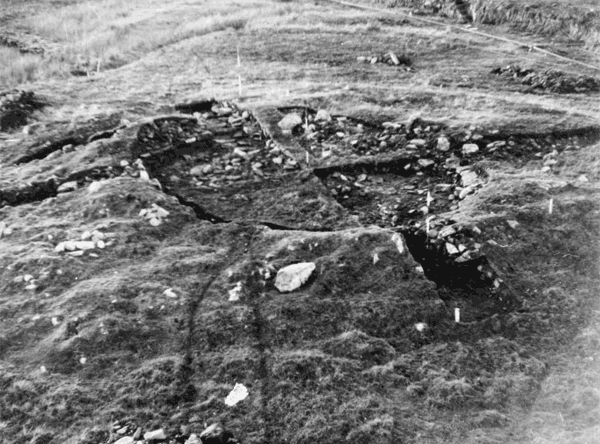
A Later Prehistoric house and Early Medieval buildings in Northern Scotland: excavations at Loch Shurrery and Lambsdale Leans, Caithness, 1955, with a note on Lower Dounreay
Vol. 5 (2003)A Later Prehistoric house and Early Medieval buildings in Northern Scotland: excavations at Loch Shurrery and Lambsdale Leans, Caithness, 1955, with a note on Lower Dounreay
Contributors: Ewan Campbell, Gordon Cook, Janet Hooper, L Wells, Colin Wallace, Jim Rideout
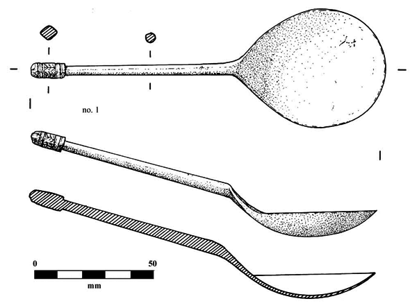
Summary: Two rescue excavations at the northern edge of a rather sparsely occupied part of the interior of Caithness are reported here, Loch Shurrery (NGR: ND 043568) and Lambsdale Leans (NGR: ND 051548), lying near to one of the largest clusters of archaeological sites in the modern county. In the event, the monuments were not threatened, and survive. Because of the limited nature of the excavation at Loch Shurrery, the main value of the evidence about the hut circle relates to its structure and dating. The excavated remains represented a medium-sized oval house with a west-facing entrance. It had an off-centre hearth of rectangular construction. It was rather different in structure to the majority of the small group of such sites which have been excavated in the northern part of the Scottish mainland, as it did not appear to have an internal ring of post holes. In addition, its western entrance is not matched at the other sites, where entrance orientations are to the south, east or south-east. The wall of the Loch Shurrery house was fairly thick and the excavation suggested that it was complex, while the entrance passageway was quite long. The existence of door checks is also an unusual feature and may relate to the entrance structures of brochs and other substantial roundhouses. Two samples of charcoal from the hearth inside the hut circle were submitted for radiocarbon dating: the determinations produce calibrated ranges (at 2-sigma) of 346-4 cal BC and 341 cal BC-1 cal AD. It is likely that most of the excavated, undecorated pottery is also Iron Age, part of a broad tradition of very coarsely tempered pottery. Not-withstanding evidence of extended occupation, the whole period of construction and occupation may have occurred within the Iron Age.
Keywords: Charcoal, Floors, Mound, Wall, Pottery, Burials, Ring Of Post Holes, Vessels, Hearth
Periods: Prehistoric, Iron Age
Locations: Caithness, Scotland, UK
-
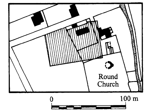
Survey at Earl's Bu, Orphir, Orkney 1989–91: geophysical work on a Late Norse estate complex
Vol. 4 (2003)Survey at Earl's Bu, Orphir, Orkney 1989–91: geophysical work on a Late Norse estate complex
Summary: The various campaigns of geophysical survey at Earl's Bu (NGR: HY 3346 0442) and its environs have added to the body of information known about the site, the early 12th-century seat of Earl Haakon Paulsson, with a round church, a large hall, a Late Norse midden and an earlier horizontal mill, confirming both considerable disturbance and potential structural traces. In some cases, the surveys have raised more questions than they have answered, particularly about some putative burnt mounds, or stone-dense midden spreads or similar anomalies. The geophysical survey has also indicated a number of features which may represent early excavation trenches. While it is often impossible to be definitive in the interpretation of geophysical anomalies, especially in Scottish contexts where geological conditions can be unhelpful in the application of archaeological geophysical survey, interpretation must be an informed process. The report concludes that more excavation of geophysical anomalies is required; the next logical stage is to excavate prior to the laying-out of the site for comprehension by the visiting public.
Keywords: Geophysical Survey, Midden, Round Church, Burnt Mounds, Horizontal Mill
Periods: Late Norse
Location: Orkney Islands, Scotland, UK
-
Bronze Age farms and Iron Age farm mounds of the Outer Hebrides
Vol. 3 (2003)Bronze Age farms and Iron Age farm mounds of the Outer Hebrides
Contributors: Geoffrey Collins, Lisbeth Crone, Alan Duffy, Andrew Dugmore, Nyree Finlay, Will Forbes, Annemarie Gibson, Paul Halstead, Kenneth Hirons, Heather James, Andrew Jones, Glynis Jones, Frances Lee, Daragh Lehane, Ann MacSween, Antoinette Mannion, Ian D Mate, Roderick McCullagh, S P Moseley, Anthony Newton, Chris Pain, Alix Powers, James Rideout, William Ritchie, E Scott, Dale Serjeantson, Andrea Smith, Nigel Thew
Summary: Hebridean sites of the coastal sand cliffs and associated machair, or sandy plain have been known for many years. Artefacts and ecofacts of various types have long been collected from archaeological sites in the eroding sand-cliffs of the machairs of the Outer Hebrides. Early in 1983, personnel of the then Central Excavation Unit of Historic Scotland's predecessor revisited very nearly all of the coastal archaeological sites then known in the Long Isle, with the specific task of identifying those at immediate threat from coastal erosion and of assessing the feasibility of their excavation or preservation. Some 32 sites were seen to be undergoing active erosion; at nine of them preservation was not being pursued and excavation was feasible. These sites were of two morphotypes: sites exposed in roughly vertical sand-cliffs and sites exposed over relatively large horzontal areas of sand deflation. It was decided to examine one sand-cliff site along its exposed face. The site selected was Balelone in North Uist (NGR: NF 719 740), its excavation designed to explore both the problems associated with the excavation of deep midden sites with complex stratigraphy and the not-inconsiderable problems of excavation in sand. In the light of the Balelone trial excavation, a new approach was called for. A structured approach aimed firstly at establishing the three-dimensional extent of the sites to be examined. Four sites were then sampled in locations at Baleshare (NGR: NF 776 615), Hornish Point (NGR: NF 758 472), South Glendale (NGR: NF 798 143) and Newtonferry (NGR: NF 89511 78288) within a rigorously-defined research framework.
Keywords: Animal Bone, Postholes, Midden, Stone Structure, Burial cairn, Pottery
Periods: Bronze Age, Iron Age
Locations: Western Isles, Scotland, UK
-
The origins of the settlements at Kelso and Peebles, Scottish Borders: archaeological excavations in Kelso and Floors Castle and Cuddyside/Bridgegate, Peebles by the Border Burghs Archaeology Project and the Scottish Urban Archaeological Trust, 1983–1994
Vol. 2 (2003)The origins of the settlements at Kelso and Peebles, Scottish Borders: archaeological excavations in Kelso and Floors Castle and Cuddyside/Bridgegate, Peebles by the Border Burghs Archaeology Project and the Scottish Urban Archaeological Trust, 1983–1994
Contributors: Adrian Cox, Derek Hall, Catherine Smith, Paul Spoerry, Caroline Wickham-Jones, Dennis Gallagher, Barbara Ford, D Henderson, D Tarling, Amanda Crowdy, Brian Moffatt, Donald Bateson, G Armstrong, Eric Cadow, Frank Moran and Dave Munro
Summary: This is a report on archaeological work in two of Scotland's less well-known medieval burghs of Kelso and Peebles (NGR: NT 7268 3402; NT 7261 3408; NT 2520 4053; NT 2057 4051).
The excavations at Wester Kelso/Floors Castle established that the original medieval burgh of Kelso or Wester Kelso was much further west than previously believed, being situated well inside the present Castle policies. That early settlement at Wester Kelso appears to have been abandoned in the 14th or 15th centuries, at the same time that the royal burgh of Roxburgh was deserted, probably as a result of the English occupation of Roxburgh Castle. The other settlement of Easter Kelso, near the abbey, survived and expanded northwards from the abbey along Roxburgh Street. The finding of a possible building terrace in Phase 1 at 13–19 Roxburgh Street indicates that settlement along the southern end of that street could date to as early as the 13th or 14th centuries. Combining the archaeological, cartographic and documentary evidence, it seems clear that 'Easter' Kelso, now Kelso, had expanded from the market area around the abbey northwards towards the Floors estate by the early 18th century.
The excavations in Peebles have provided important information on the origins of the settlement of the peninsular ridge between the Tweed and Eddleston Water. The results obtained from the excavations at the two sites in Peebles indicate that settlement of the ridge began in the 12th century, soon after the establishment of the royal castle and burgh by David I (1124–53). At both sites, after initial dumping of rubbish, possibly to raise the ground level to counter flooding, occupation, in the form of stone structures, can be dated to the 14th century at the latest, with probable earlier dumping of domestic refuse in the 12th and 13th centuries. The street of Bridgegate was apparently laid out in the 13th or 14th centuries when the excavated site was divided into three properties aligned on that street, two of which had stone buildings erected on them. Alternatively, Bridgegate may have been the initial focus of settlement on the east side of the Eddleston, providing the access route from the east into Old Town, where a pilgrimage centre had been established at the Cross Kirk in 1261, and the location of the tolbooth (Bridgegate Building 4) in it suggests that this street was originally more important than High Street. It is noteworthy that all eight medieval buildings excavated at the two Peebles sites were of stone construction. Peebles tolbooth, the civic centre of the burgh, is the only medieval tolbooth site in Scotland to have been excavated.
Keywords: Settlement, Pottery, Abbey, Plant remains, Animal remains, Castle
Period: Medieval
Locations: Scottish Borders, Scotland, UK
-
Dundrennan Abbey: archaeological investigation within the south range of a Cistercian house in Kirkcudbrightshire (Dumfries & Galloway), Scotland
Vol. 1 (2001)Dundrennan Abbey: archaeological investigation within the south range of a Cistercian house in Kirkcudbrightshire (Dumfries & Galloway), Scotland
Contributors: Stephen Carter, Naomi Crowley, Andrew Dunn, Harry Kenward, Coralie Mills, Tanya O'Sullivan, Alan Radley, Dorothy Rankin, Robert Will, Geoquest Associates, David Connolly, Ruby Céron-Carrasco
Summary: The remains of the south-west corner of the 12th-century Cistercian abbey cloister at Dundrennan (NGR: NX 7492 4750) were cleared of rubble and 19th-century landscaping infill over four seasons of fieldwork in the early 1990s. Elements of the warming house, novice's day room, great drain and latrine block undercroft were revealed. Coupled with a short programme of geophysical survey and test-trenching, new evidence of the sequence of building for the abbey was revealed by excavation. The project was funded by Historic Scotland.
Keywords: Sewers, Ecclesiastical Architecture, Abbey, Geophyiscal survey, Fieldwork, Cistercian House, Block Undercroft, Cistercian Abbey Cloister, Gardens, Flooding, Cloister, Midden, Trial Trenches, Timber Buildings, Excavations, Sherds, Ceramic
Periods: medieval, late medieval, 12th century
Location: Dumfries and Galloway, Scotland, UK
Previous
111-115 of 115
